Urschak
|
Urschak Уршак, Өршәк |
||
|
|
||
| Data | ||
| Water code | RU : 10010201412111100019897 | |
| location | Bashkortostan ( Russia ) | |
| River system | Volga | |
| Drain over | Belaya → Kama → Volga → Caspian Sea | |
| source | in the southwest of Bashkortostan 53 ° 31 ′ 22 ″ N , 55 ° 7 ′ 54 ″ E |
|
| muzzle | south of Ufa in the Belaja coordinates: 54 ° 35 ′ 31 ″ N , 55 ° 58 ′ 24 ″ E 54 ° 35 ′ 31 ″ N , 55 ° 58 ′ 24 ″ E |
|
| Mouth height |
85 m
|
|
| length | 193 km | |
| Catchment area | 4230 km² | |
| Drain |
MQ |
13.5 m³ / s |
|
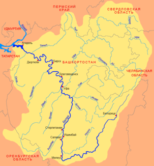
Location of the Urschak (Урша́к) in the catchment area of the Belaya |
||
The Urschak ( Russian Урша́к ; Bashkir Өршәк ) is a left tributary of the Belaja in Bashkortostan in the European part of Russia .
The Urschak rises in the southwest of Bashkortostan. It flows mainly in a northerly direction. The Urschak meets the Belaja on the left south of the city of Ufa . The river has a length of 193 km. It drains an area of 4230 km². The mean discharge of the Urschak is 13.5 m³ / s. The Urschak is covered with ice between November and the end of April.
