
Bavona Valley


The Bavonatal ( Italian Valle Bavona ) is a valley in the northwest of the canton of Ticino in Switzerland .
geography
The Bavona valley flows into the Maggia valley at Bignasco . The Bavona flows through the valley . It rises around 560 meters over a length of 12 kilometers.
The valley is a narrow U-shaped glacial trough valley . The many boulders and stones that litter the valley floor date from the time when the glaciers retreated and from landslides like that of 1594 at Fontana.
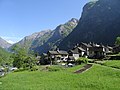
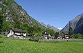
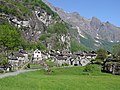
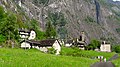
In the valley floor are twelve hamlets (Terre), whose inhabitants were called Terrieri . Due to the lack of a road until 1950 and the deliberately non-existent electricity even today, the uniform townscape with the traditional stone houses (so-called rusticos ) have been preserved, even if the latter have sometimes lost their original character due to additional decorations such as geraniums and wagon wheels. Electricity connections are prohibited in the valley for reasons of tradition protection, even if this prohibition is repeatedly undermined by the residents in a variety of ways (generators, small turbines, solar cells, car batteries).
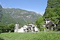
The hamlets from south to north are called: Mondada , Fontana , Alnedo , Sabbione , Ritort (Ritorto) , Foroglio , Rosed (Roseto) , Fontanelada (Fontanellata) , Faed (Faedo) , Bolla , Sonlèrt (Sonlerto) , San Carlo . The best known is Foroglio with its large waterfall. With the exception of San Carlo , the farthest village in the valley that belonged to Bignasco , all were part of Cavergno . In 2006 the whole valley was merged into the political municipality of Cevio . From San Carlo a cable car leads up to the Robiei reservoir of the Maggia power plants , starting point for tours on the Basòdino or the Cristallina hut .
Hamlet in Val Bavona, up the valley

Fontana

Sabbions
Ritorto

Foroglio
Roseto
Fontanellata
Sonlerto
San Carlo


history
The valley was abandoned around 1500 because of the hardening climate. At the back of the valley are the ruins of the village of Prèsa di San Carlo . The residents settled in Cavergno or Bignasco and in the spring they moved their animals back into the valley to the various altitudes (tiered economy or transhumance ), where they owned homes and stables. To manage the scarce meadows - seventy percent of the area is unproductive - steep stairways were built in higher areas and meadows hanging on large boulders (prati pensili) were created. Stables, cellars and shelters (splüi) were set up under large, fallen boulders.

Sabbione: Splüi di Inselmitt on the Transhumance Path

Alnedo: Splüi di chieuri

Alnedo: Prati pensili
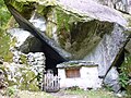
Mondada: Splüi del forno


In summer the valley is inhabited by almost 2,000 people, in winter it is uninhabited. The road can be closed in bad weather conditions (landslides, snow). In 1983 the municipalities of Cavergno and Bignasco created a zoning plan with strict usage and construction criteria that is intended to protect the valley's cultural assets. In the same year the valley was included in the federal inventory of landscapes and natural monuments of national importance. In 1990 the Fondazione Valle Bavona was set up to monitor these regulations. The foundation takes care of the preservation of the cultural, natural and landscape heritage. It concludes management contracts with the owners of the land so that the land that has been covered with bushes is converted back into meadows and regularly mowed.
reachability
The Bavona valley can be reached from Locarno by car or bus in around an hour. If the conditions are good, you can hike from the Bedrettotal via the Cristallinahütte (Cristallinapass) into the Bavona valley.
The regional long-distance hiking trail Sentiero Cristallina (signposted as hiking route no. 59) leads over 41 km in three stages from Airolo (Bedretto valley) to Bignasco or vice versa. The route runs on the section from Foroglio to Mondada on the well-signposted transhumance theme path (Percorso della Transumanza).
The church of Gannariente

The church of Gannariente, built in 1595, stands between Sonlerto and San Carlo. A procession has been held on the first Sunday in May for around 400 years regardless of the weather. It starts at 6 a.m. in Cavergno and takes about nine kilometers through all the hamlets up to the Bavona valley for four hours. There is prayer and singing during the procession. Mass is read in the church of Gannariente, then the fields are blessed. The festival ends with lunch and an auction of the gifts.
tourism
- Excursion Robiei – Lago di Cavagoli
literature
- Daniela Pauli Falconi: Valle Bavona. In: Historical Lexicon of Switzerland .
- Martino Signorelli: Storia della Valmaggia. Tipografia Stazione SA, Locarno 1972, pp. 53, 56, 84, 175, 240, 253, 256-287, 288-289, 336, 349, 386-387, 408.
- Aldo and Nora Cattaneo: Stories and Paths of Val Bavona . Publisher Armando Dadò, Locarno 1998.
- Val Bavona . Val Bavona Foundation.
- Federico Balli, Giuseppe Martini: Val Bavona - a touch of days gone by, Edition Stiftung Val Bavona and Armando Dadò, Locarno.
- Val Bavona - manual for the renovation of the rustici . Edition Val Bavona Foundation.
- Luigi Martini: Transhumance and Alpine farming in Val Bavona . Edition Val Bavona Foundation.
- Giuseppe Brenna: Giuseppe Zan Zanini and the Val di Foiòi (Val Bavona) . Salvioni Edizioni, Bellinzona 2010.
- Giuseppe Brenna and Luigi Martini: Alpi di Val Bavona, Informazioni storiche e itinerari . Salvioni Edizioni, Bellinzona e Armando Dadò, Locarno 2011, ISBN 978-88-7967-289-4 .
- Luigi Martini et al .: Terre di Val Bavona. Il sole dietro il crepuscolo . Edition Val Bavona and Armando Dadò Foundation, Locarno 2015.
exhibition
- Valle Bavona. A Ticino mountain valley like no other . Exhibition at the Heimatschutzzentrum des Schweizer Heimatschutz , Villa Patumbah , Zurich, from November 6, 2015 to May 29, 2016. [1]
Web links
- Description of the Bavona Valley with video of the waterfall
- Federal inventory ISOS: Valle Bavona (PDF; 14.2 MB)
- Val Bavona Foundation
- alpi-ticinesi - Val Bavona
- Stepped paths in the sky above the Val Bavona
- Valle Bavona: ASTi, catalogo dei fondi fotografici
- Laghetto d'Antabia on ti.ch/fileadmin