Vanajõgi
| Vanajõgi | ||
|
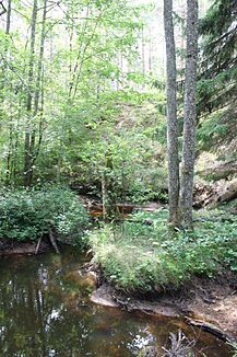
Glacial valley on the lower reaches |
||
| Data | ||
| location | Hiiumaa , Estonia | |
| River system | Vanajõgi | |
| source | Bog of Õngu | |
| muzzle |
Baltic Sea coordinates: 58 ° 52 '49 " N , 22 ° 24' 39" E 58 ° 52 '49 " N , 22 ° 24' 39" E
|
|
| length | 9.1 km | |
| Catchment area | 16.7 km² | |
| Communities | Hiiumaa | |
| Residents in the catchment area | 200 | |
The Vanajõgi River flows on the second largest Estonian island, Hiiumaa (German Dagö ).
description
The Vanajõgi River is 9.1 kilometers long. Its catchment area covers 16.7 km².
The river has its source in Õngu ( Õngu soo ) bog near the 2.7 hectare Tihu Väikejärv lake near the village of Leigri in the Tihu ( Tihu maastikukaitseala ) nature reserve .
It then mostly flows in a westerly direction. Spring is especially rich in water.
At the lower reaches the river crosses the glacial valley Vanajõgi ( Vanajõe org ). On the banks of the river, a natural history trail through the largely untouched landscape was laid out.
The Vanajõgi then continues to flow through a dune landscape . It flows into the Mardihansu Bay ( Mardihansu laht ) in the Baltic Sea near the village of Jõesuu .
fauna
In late autumn the sea trout spawn in the clear water of the river . The glacial valley on the lower reaches has been under nature protection since 1962.
Web links
- Entry in the Estonian environmental register
- Full description (Estonian)
- Educational trail in the Vanajõgi valley (German)
