Viamão
| Viamão | ||
|---|---|---|
|
Coordinates: 30 ° 5 ′ S , 51 ° 1 ′ W Viamão on the map of Rio Grande do Sul
|
||
| Basic data | ||
| Country | Brazil | |
| State | Rio Grande do Sul | |
| City foundation | September 14, 1741 | |
| Residents | 239,234 (2010 census) | |
| - in the metropolitan area | 3,760,644 | |
| City insignia | ||
| Detailed data | ||
| surface | 1494.2 | |
| Population density | 169.5 inhabitants / km 2 | |
| height | 111 m | |
| prefix | 51 | |
| Time zone | UTC −3 | |
| City Presidency | Alex Sander Alves Boscaini ( PT ) | |
| Website | ||
| Location of Viamão in Rio Grande do Sul | ||
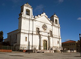
| Igreja da Conceição | ||
Viamão is a city in the southernmost Brazilian state of Rio Grande do Sul in the metropolitan area east of Porto Alegre .
The city lies on the Rio Guaíba and the Lagoa dos Patos . The origin of the city name is unknown, it could come from “Vi a mão” / “I saw the hand”, since the five tributaries of the Rio Guaíba are reminiscent of the five fingers of a hand.
Web links
Individual evidence
- ↑ Population data from the 2010 IBGE census , 2010 (PDF, Portuguese; 51 kB), accessed on March 5, 2011


