Kem (White Sea)
|
Kem Кемь, Kemijoki |
||
| Data | ||
| Water code | RU : 02020000812102000002697 | |
| location | Republic of Karelia ( Russia ) | |
| River system | Kem | |
| Drain over | Kem → White Sea | |
| origin | in the lake Nizhneje Kuito 64 ° 52 ′ 44 ″ N , 31 ° 56 ′ 21 ″ E |
|
| Source height | 100 m | |
| muzzle | near Kem in the White Sea Coordinates: 64 ° 57 ′ 19 ″ N , 34 ° 40 ′ 28 ″ E 64 ° 57 ′ 19 ″ N , 34 ° 40 ′ 28 ″ E |
|
| Mouth height | 0 m | |
| Height difference | 100 m | |
| Bottom slope | 0.52 ‰ | |
| length | 191 km | |
| Catchment area | 27,700 km² | |
| Discharge at the Juschkosero A Eo gauge : 19,800 km² Location: 172 km above the mouth |
MNQ 1928/1987 MQ 1928/1987 Mq 1928/1987 MHQ 1928/1987 |
90 m³ / s 190 m³ / s 9.6 l / (s km²) 353 m³ / s |
| Discharge at the Schomba A Eo gauge : 24,700 km² Location: 87 km above the mouth |
MNQ 1960/1986 MQ 1960/1986 Mq 1960/1986 MHQ 1960/1986 |
109 m³ / s 254 m³ / s 10.3 l / (s km²) 447 m³ / s |
| Discharge at the Poduschemje A Eo gauge : 27,900 km² Location: 18 km above the mouth |
MNQ 1917/1966 MQ 1917/1966 Mq 1917/1966 MHQ 1917/1966 |
97 m³ / s 256 m³ / s 9.2 l / (s km²) 498 m³ / s |
| Discharge at the Putkinskaya A Eo gauge : 27,700 km² Location: 5.7 km above the mouth |
MNQ 1968/1988 MQ 1968/1988 Mq 1968/1988 MHQ 1968/1988 |
134 m³ / s 279 m³ / s 10.1 l / (s km²) 532 m³ / s |
| Left tributaries | Kepa , Shomba | |
| Right tributaries | Tschirka-Kem , Ochta | |
| Flowing lakes | Euschijarvi , Chapjarwi , Julijarwi , Juschkojarvi , Kurojarvi , Kuljanjarvi , Panojarvi | |
| Small towns | Kem | |
|
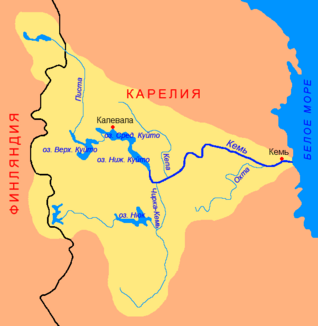
The catchment area and course of the River Kem |
||
Kem ( Russian Кемь , Finnish Kemijoki ) is a 191 km long river in the Republic of Karelia in Russia . It has its origin in Lake Nizhneye Kuito and flows through a number of lakes to the White Sea . There is a chain of five hydroelectric plants along the river. The city of the same name Kem is located at the mouth of the Kem. Important tributaries are Tschirka-Kem and Ochta from the right and Kepa and Schomba from the left.
Hydropower plants
- Yushkoserskaya GES (1971–1980, 18 MW)
- Beloporoschskaja GES (1992–1999, 130 MW)
- Kriwoporoschskaja GES (1977–1991, 180 MW)
- Poduschemskaja GES (1968–1971, 48 MW)
- Putkinskaya GES (1962–1967, 84 MW)
Web links
Commons : Kem - collection of images, videos and audio files
- Kem at the Jurjachmja gauge - hydrographic data from R-ArcticNET
Individual evidence
- ↑ a b Kem in the State Water Directory of the Russian Federation (Russian)
- ↑ a b Article Kem in the Great Soviet Encyclopedia (BSE) , 3rd edition 1969–1978 (Russian)
- ↑ Kem at the Juschkosero gauge - hydrographic data from R-ArcticNET
- ↑ Kem at the Schomba gauge - hydrographic data at R-ArcticNET
- ↑ Kem at the Poduschemje gauge - hydrographic data from R-ArcticNET
- ↑ Kem at the Putkinskaya gauge - hydrographic data from R-ArcticNET

