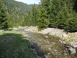
Viggarbach
|
Viggarbach Mühltaler Bach, Mühlbach |
||
|
Viggarbach near the Meißnerhaus |
||
| Data | ||
| location | Tyrol , Austria | |
| River system | Danube | |
| Drain over | Sill → Inn → Danube → Black Sea | |
| source | Blauer See 47 ° 11 ′ 30 ″ N , 11 ° 31 ′ 2 ″ E |
|
| Source height | 2235 m above sea level A. | |
| muzzle | in the Sill coordinates: 47 ° 10 '37 " N , 11 ° 25' 26" E 47 ° 10 '37 " N , 11 ° 25' 26" E |
|
| Mouth height | 809 m above sea level A. | |
| Height difference | 1426 m | |
| Bottom slope | 14% | |
| length | 10.2 km | |
| Catchment area | 20.45 km² | |
| Communities | Elbows | |
The Viggarbach , also called Mühltaler Bach or Mühlbach , rises from the Blue Lake and flows through the Viggartal in the Tux Alps in a north to south-westerly direction and flows into the Sill below Ellbögen . The stream has a length of 10 kilometers.
The raging brook retains water quality class I throughout its course and is particularly dangerous during floods and heavy rain. However, since the surrounding communities are a little further away from the water, there is less danger for housing developments.
The Blue Lake forms the origin of the Viggarbach, has an area of approx. 0.79 hectares and water quality class I.
