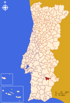
Vila de Frades
| Vila de Frades | |||||
|---|---|---|---|---|---|
|
|||||
| Basic data | |||||
| Region : | Alentejo | ||||
| Sub-region : | Baixo Alentejo | ||||
| District : | Be yes | ||||
| Concelho : | Vidigueira | ||||
| Coordinates : | 38 ° 13 ′ N , 7 ° 49 ′ W | ||||
| Residents: | 928 (as of June 30, 2011) | ||||
| Surface: | 25.62 km² (as of January 1, 2010) | ||||
| Population density : | 36 inhabitants per km² | ||||
| politics | |||||
| Address of the municipal administration: | Junta de Freguesia de Vila de Frades R. Poeta João X Matos 6 7960–456 Vila de Frades |
||||
| Website: | www.viladefrades.com | ||||
Vila de Frades is a municipality in the Alentejo ( Portugal ) in the district of Vidigueira with an area of 25.6 km² and a population of 928 inhabitants (as of June 30, 2011). The population density is 36.2 inhabitants per km².
Vila de Frades was an independent county town until 1854 and by 1849 had 2,877 inhabitants. Then Vila de Frades was assigned to the district of Vidigueira . The Portuguese writer Fialho de Almeida was born in Vila de Frades and in 2007 he celebrated his 150th birthday.
Buildings
- Ruins and archaeological site of the Roman settlement of São Cucufate , which later housed the São Cucufate monastery
- Chapel of São Brás (Vila de Frades) | Capela de São Brás
- Monastery of Nossa Senhora da Assunção
- Main church of Vila de Frades
- The clock tower of Vila de Frades (Torre do Relógio) from 1890, which is in Rua Luis de Camões; the pendulum clock still works today
- Casa do Arco Museum
sons and daughters of the town
- José Valentim Fialho de Almeida (1857–1911), writer and journalist
Individual evidence
- ↑ www.ine.pt - indicator resident population by place of residence and sex; Decennial in the database of the Instituto Nacional de Estatística
- ↑ Overview of code assignments from Freguesias on epp.eurostat.ec.europa.eu
Web links
- Map of the Freguesia Vila de Frades at the Instituto Geográfico do Exército
- Vitifrades wine event


