Vilarinho (Lousã)
| Vilarinho | ||||||
|---|---|---|---|---|---|---|
|
||||||
| Basic data | ||||||
| Region : | Centro | |||||
| Sub-region : | Region of Coimbra | |||||
| District : | Coimbra | |||||
| Concelho : | Lousã | |||||
| Coordinates : | 40 ° 8 ′ N , 8 ° 13 ′ W | |||||
| Residents: | 2679 (as of June 30, 2011) | |||||
| Surface: | 25.31 km² (as of January 1, 2010) | |||||
| Population density : | 106 inhabitants per km² | |||||
| politics | ||||||
| Website: | www.jf-vilarinho.pt | |||||
Vilarinho is a village and former municipality in the district of Lousã , in Portugal .
history
The first document to prove the existence of the place dates back to 1360, although some historians suggest that the place is of earlier origin. The name Vilarinho could be derived from the Roman word "villa", which could indicate the existence of a small Roman settlement. The origin of the name could also be in the baroque era. Vilarinho means nothing else than "small town". The name Vilarinho can be found in several places in Portugal.
During the Napoleonic invasions in the 14-16th centuries, Vilarinho March 1811 - like many of the surrounding villages - suffered some damage when the French invasion troops and their pursuers, the Anglo-Portuguese army under Wellington , passed the place. In nearby Foz de Arouce , the battle of Foz de Arouce took place on March 15th .
The previously independent municipality of Vilarinho was merged with the municipality of Lousãs with the territorial reform of Portugal in 2013 , to form the new municipality of Lousã e Vilarinho .
Attractions
The baroque church from 1750 should be emphasized. It is consecrated to St. Peter. The figures on the facade show the Holy Mother of God with child, Saint Peter and Saint Paul. These figures date from the 16th century. Red sandstone was used as a building material for the church and figures . The church tower is designed for four bells, but only three bells were hung, successively in the years 1822, 1893 and 1904. The nave consists of one room. The main and side altars are from the 18th century.
administration
Vilarinho is a former municipality ( freguesia ) in the district ( concelho ) of Lousã in the district of Coimbra . 2679 inhabitants live there on an area of 25.3 km² (as of June 30, 2011).
The following localities are in the area of the former municipality:
- Casais
- Prilhão
- Reguengo
- Vilarinho
In the course of the municipal reorganization of Portugal after the local elections on September 29, 2013, the municipality was dissolved and integrated into the newly created municipality União das Freguesias de Lousã e Vilarinho .
Products
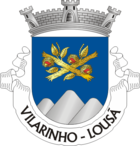
Favored by the microclimate in Vilarinho at the foot of a mountain range in the Serra da Lousã , chestnut trees were traditionally planted . A district of Vilarinho is called “Soito”, which means nothing more than chestnut grove. The chestnut or chestnut served as a flour substitute in earlier times. The coat of arms shows two golden chestnut branches with open fruit stands on a yellow-blue background. Three mountain hills are indicated below, which indicate the mountainous location of the village. Another important product of the region is the heather - honey , which is characterized by a pronounced bitter taste and a dark and viscous consistency.
Sons and daughters of the church
- Vicente Ferrer Neto de Paiva (1798–1886), philosopher and politician, professor at the University of Coimbra , 1857 Minister of Justice
Web links
- Map of the Freguesia Vilarinho (Lousã) at the Instituto Geográfico do Exército
- Vilarinho website
Individual evidence
- ↑ www.ine.pt - indicator resident population by place of residence and sex; Decennial in the database of the Instituto Nacional de Estatística
- ↑ Overview of code assignments from Freguesias on epp.eurostat.ec.europa.eu
- ↑ Legal text (Port .; PDF access 2.4 MB), accessed on February 18, 2015


