Vomano
| Vomano | ||
|
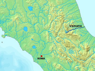
The course of the Vomano |
||
| Data | ||
| location | Teramo Province , Abruzzo , Italy | |
| River system | Vomano | |
| River basin district | Central Apennines | |
| source | Monte S. Franco, Gran Sasso massif 42 ° 28 ′ 33 ″ N , 13 ° 21 ′ 32 ″ E |
|
| Source height | 1200 m slm | |
| muzzle | at Roseto degli Abruzzi in the Adriatic Coordinates: 42 ° 39 ′ 19 ″ N , 14 ° 2 ′ 17 ″ E 42 ° 39 ′ 19 ″ N , 14 ° 2 ′ 17 ″ E |
|
| Mouth height | 0 m slm | |
| Height difference | 1200 m | |
| Bottom slope | 18 ‰ | |
| length | 68 km | |
| Catchment area | 782 km² | |
|
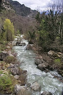
The Vomano River |
||
The Vomano is a river in the Italian region of Abruzzo about 68 km long.
geography
The Vomano river has its source on Monte San Franco in the Gran Sasso massif at an altitude of about 1200 m. The Vomano has an average water flow of approx. 15 m³ / s. It crosses the Abruzzo Apennines and the territory of the Gran Sasso National Park . The Vomano continues to flow eastwards before flowing into the Adriatic Sea at Roseto degli Abruzzi .
In 1995, a large part of the river's catchment area was placed under nature protection. The Parco territoriale attrezzato del Fiume Vomano was established with an area of 335 hectares.
Web links
Commons : Vomano - collection of images, videos and audio files
Individual evidence
- ↑ Istituto Superiore per la Protezione e la Ricerca Ambientale (ed.): Note illustrative della Carta Geologica d'Italia alla scala 1: 50,000 foglio 349 Gran Sasso d'Italia o. O., o. JS 191 PDF
- ^ Parco territoriale attrezzato del Fiume Vomano
- ↑ Area protetta (web.archive.org)


