
From-Ruhr-to-Ruhr cycle path
| From-Ruhr-to-Ruhr cycle path | |
|---|---|

|
|
| overall length | about 55 km |
| location | North Rhine-Westphalia , Germany |
| map | |

|
|
| Places along the way | Schee , Hattingen , Wetter- Wengern , Silschede |
| Flooring | Water-bound ceiling , little asphalt |
| Height difference | 180 m |
| difficulty | light
(Albringhausen-Silschede: difficult) |
| Traffic volume | little |
| Connection to | RuhrtalRadweg , Kaiser-Route , Ruhrgebiet circuit |
The Von-Ruhr-zur-Ruhr-Radweg is a circular cycle route in North Rhine-Westphalia . It is located in the cities of Hattingen , Sprockhövel , Gevelsberg , Wetter and Witten . It is about 55 km long and is signposted. The bike path runs largely on former railway lines. An approximately 2 km long section between Silschede and Albringhausen has not yet been developed. The highest point is at Schee ( 250 m ), the lowest on the Ruhr at Hattingen ( 70 m ).
Signage and route quality
The route is integrated into the NRW cycling network. The logo shows a yellow bicycle, two green hills, a red railway line and the blue Ruhr with the words “Von Ruhr zur Ruhr”.
The many surrounding grilles disrupt the otherwise smooth running of the path a little. With bike trailers , tandems, or fully loaded bikes, it will be difficult to get through in some places. Most of the paths are not paved, but they are in good condition. It is advisable to drive the route in such a way that the steep section Wengern-Silschede is driven downwards - i.e. counterclockwise. The following route descriptions describe the course in clockwise direction.
Sections
The route can be divided into four sections analogous to the former railway lines.
Schee - Hattingen
Elevation profile: Schee 250 m - Hattingen 90 m
Length: 13 km
This section runs on the former Wuppertal-Wichlinghausen-Hattingen railway line . The gradient is a maximum of 2%. The Schulenberg tunnel , which is just before Hattingen, was opened to bicycle traffic on September 23, 2008. The former train stations of Sprockhövel (1884), Bossel and Schee (1886) have been preserved.
Hattingen - Wengern
Elevation profile: Hattingen 90 m - Wengern 84 m
Length: 23 km
On this section the path leads along the Ruhr without any significant inclines and runs parallel to the RuhrtalRadweg . The use of the Ruhr valley ferry Hardenstein is possible. In Wengern there is a short, steep passage (crossing under the railway). The cycle path uses a section of the Ruhr Valley Railway .
Wengern - Silschede
Elevation profile: Wengern 84 m - Silschede 230 m
Length: 10 km
The reconstruction of the former Witten – Wengern West / Schwelm railway line had to be postponed several times. The section from Witten to Albringhausen was completed in August 2017. This means that almost the entire circuit is passable with slight inclines. The Albringhausen - Silschede section is to be laid out from 2018-2019, but not on the railway line.
Silschede - Schee
Elevation profile: Silschede 230 m - Schee 250 m
Length: 9 km
This section runs on the route of the former Schee – Silschede railway line . It has been completely rebuilt as a cycle path and has very little incline. Shortly before Schee, the path deviates from the old route (the short bypass has a moderately steep 15 meters in altitude).
More bike paths
- In Silschede, a connection to the former Schlebusch-Harkorter coal railway is to be built later . It leads to Hagen- Haspe and is already partially passable today, but not signposted.
- In Schee there has been a connection to Wuppertal since December 19, 2014 . See Wuppertal Northern Railway .
gallery

Branch in snow; left the route to Hattingen, right the route to Silschede
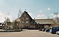
The former Sprockhövel train station (Niedersprockhövel)

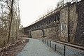
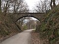
Hackertbrücke between Sprockhövel (Stüter) and Hattingen

Schuleberg tunnel in Hattingen

Interior view of the Schulenberg tunnel
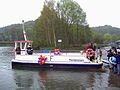
Ruhr Valley ferry
Ruhr Valley Cycle Path
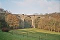
Wengern Viaduct

Bike path near Silschede
Between Niedersprockhövel and Hattingen ( Bredenscheid )


Individual evidence
- ↑ http://www.derwesten.de/staedte/nachrichten-aus-wetter-und-herdecke/von-ruhr-zu-ruhr-fuer-neuen-radweg-fallen-die-baeume-id8590373.html
- ↑ http://www.derwesten.de/staedte/hattingen/rad-rundkurs-an-der-ruhr-wird-weitergebaut-id9040198.html
- ↑ Dream bike path connects the Ruhr area with Bergisches Land - Ruhr area - Nachrichten - WDR. In: www1.wdr.de. Retrieved August 29, 2017 .
- ↑ Bike paths in Wetter. In: www.stadt-wetter.de. Retrieved August 30, 2017 .
Web links
- Description and information material on the “From Ruhr to Ruhr” cycle path. In: ennepe-ruhr-tourismus.de. Retrieved August 29, 2017 .
- GPS data of the cycle path on gps-tour.info
- GPS data of the bike path on Bikemap
- GPS data of the bike path on gpsies
- The route in the open bike map (abbreviation RZR)