Wülfershausen (Osthausen-Wülfershausen)
|
Wülfershausen
Community Osthausen-Wülfershausen
Coordinates: 50 ° 50 ′ 47 " N , 11 ° 5 ′ 22" E
|
|
|---|---|
| Height : | 352 (340-360) m |
| Residents : | 169 (June 1, 2010) |
| Incorporation : | May 16, 1968 |
| Postal code : | 99310 |
| Area code : | 036200 |
|
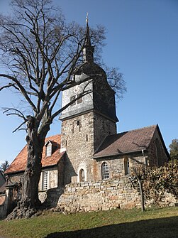
Church in Wülfershausen
|
|
Wülfershausen is a district of the municipality of Osthausen-Wülfershausen in the Ilm district in Thuringia .
geography
The village is about 13 km east of Arnstadt and 20 kilometers south of Erfurt . The A 4 runs about 8 kilometers north of the village and the A 71 about 6 kilometers west , which can be reached via the Arnstadt-Süd junction . Today Wülfershausen is a typical cluster village . The village of Osthausen is about 1 km to the east. The Elleber Bach rises in the local area and winds its way west towards Alkersleben , where it flows into the Wipfra after 3,800 m . The airfield Arnstadt-Alkersleben takes up part of the municipality in the southwest, about 1.8 hectares .
history
Wülfershausen was first mentioned in a document in 1268. In the village there were five manors : Schieferhof, Sandighof, Oberritterhof, Poseckscher Court and the Niederritterhof. Some of the buildings have been torn down or have fallen into disrepair. Until 1918 the place belonged to the sovereignty of the principality of Schwarzburg-Sondershausen .
On May 16, 1968 it was merged with the Osthausen community to form the Osthausen-Wülfershausen community.
Attractions
- St. Vitus village church , built probably in the 9th century; it is one of the oldest church buildings in Thuringia.
Web links
Individual evidence
- ^ Website of the VG Riechheimer Berg
- ↑ Municipalities 1994 and their changes since January 1, 1948 in the new federal states , Metzler-Poeschel publishing house, Stuttgart, 1995, ISBN 3-8246-0321-7 , publisher: Federal Statistical Office
