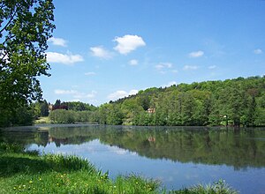
Niederwürzbacher Weiher
| Niederwürzbacher Weiher | ||
|---|---|---|

|
||
| View over the pond towards Gut Junkerwald | ||
| Geographical location | On the outskirts of Niederwürzbach on the L 111 | |
| Tributaries | Würzbach and Geißbach | |
| Drain | Wurzbach | |
| Places on the shore | Niederwürzbach | |
| Data | ||
| Coordinates | 49 ° 14 '43 " N , 7 ° 11' 36" E | |
|
|
||
| Altitude above sea level | 226 m above sea level NHN | |
| surface | 12 ha | |
The Niederwürzbacher Weiher (also Würzbacher pond ) is a 12-hectare lake in Saarland Niederwürzbach in Saarpfalz district .
location
The Niederwürzbacher Weiher extends along the L 111 on the outskirts of Niederwürzbach from north-west to south-east direction in the valley of the Würzbach . At the western end a peninsula protrudes into the lake and divides it. The northern arm of the pond receives the water from the Geißbach . There is an excursion restaurant and a villa-like house on the peninsula. A road runs over the dam in the southeast. The Würzbach flows into and out of the pond. The town's train station is also on the shores of the lake on the railway line from Saarbrücken to Pirmasens . The lake is part of the Bliesgau Biosphere Reserve .
history
The pond was created artificially. In 1564 the geographer Tilemann Stella describes him as follows in his description and map of the Zweibrücken and Kirkel offices:
" The new pond hears going Bliscastell, is 1250 steps long on one horror and 750 steps and 80 wide on the other "
The associated map shows the old course of the district and sovereign border along the two horns of the pond. In 1781, through an exchange of territory, the area between the two horns of the pond, on which the Junkerwald estate today exists, came to the Imperial Counties of von der Leyen .
At this time the lake became part of a stately English garden , which Countess Marianne von der Leyen had laid out at the end of the 18th century. Marianne von der Leyen had two summer residences built on the bank, the Annahof , an estate that is now a hotel, and the Monplaisir house (also known as the Red House), which is now privately owned.
On a hill on the peninsula jutting out into the lake is the Junkerwald estate, a villa that was owned by the hospital doctor and doctor for the poor, living in St. Ingbert, at the beginning of the 20th century. Karl Ehrhardt had it built for his daughter.
Current usage
The lake is used as a local recreation area. On the north shore of the lake there is a sunbathing lawn with a beach volleyball field and a children's playground as well as a municipal campsite with parking spaces for mobile homes. A promenade leads around the lake and is connected to the region's network of hiking trails.
literature
- Ralf Schneider: The English Gardens at Niederwürzbacher Weiher. Röhrig Universitätsverlag, St. Ingbert 2005, ISBN 3-86110-399-0 .
Individual evidence
- ^ Tilemann Stella: Thorough and thorough description of the baider ambter Zweibrücken and Kirckel, how the same located in 1564 . Editor: Eginhard Scharf. Historischer Verein, Zweibrücken 1993, p. 181. ISBN 3-924171-15-7
- ↑ a b History of Gut Junkerwald
- ^ History of the Niederwürzbacher Weiher at saarlandbilder.net

