
Geißbach (Wurzbach)
|
Geißbach Frohnsbach (Fronsbach) |
||
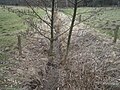
 Upper Geißbachtal 200 m behind the source looking down the valley |
||
| Data | ||
| Water code | DE : 2642832 | |
| location |
Saar-Nahe-Bergland
|
|
| River system | Rhine | |
| Drain over | Würzbach → Blies → Saar → Moselle → Rhine → North Sea | |
| source | near the Geistkircherhof 49 ° 16 ′ 31 ″ N , 7 ° 11 ′ 9 ″ E |
|
| Source height | 268 m above sea level NN | |
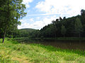
| muzzle | in the Würzbacher Weiher in the Würzbach Coordinates: 49 ° 14 '59 " N , 7 ° 11' 7" E 49 ° 14 '59 " N , 7 ° 11' 7" E
|
|
| length | 3 km | |
| Catchment area | 4.14 km² | |
| Left tributaries | Blade moat | |
| Reservoirs flowed through | Saw antlers | |
| Medium-sized cities | St. Ingbert , Blieskastel | |
The Geißbach (also Frohnsbach and Fronsbach ) is a small brook that flows in the Hassel district of the city of St. Ingbert and the Niederwürzbach district of the city of Blieskastel . It is a left tributary of the Würzbach .
Its valley is a popular recreational area.
geography
course
The Geißbach rises near the Geistkircherhof between the L 119 ( Kaiserstraße ) and the Saarbrücken – Mannheim railway line and flows south to the Niederwürzbacher Weiher .
After crossing under the railway line, the stream runs through an open meadow and pasture area that narrows more and more to a narrow valley in the Sankt Ingbert-Kirkeler forest area . In earlier times the brook was dammed into a chain of five ponds over a great length, some of which the dams are still visible in the terrain. Of these ponds, apart from the Würzbach pond, only the saw antlers , which is used as a fish pond, have survived . Before the Second World War, the saw antler was used as a bathing pond (with changing rooms). The foundations of an earlier development can still be seen on its dam.
The water from the Uhubrunnen flows in from a small valley from the left.
Tributaries
- Fronbachgraben ( left ), 0.1 km
- Klingengraben ( left ), 0.9 km
Nature reserve and vegetation
While the upper reaches of the stream are surrounded by pastures, large sections in the middle and lower parts have been designated as the Frohnsbachtal - Geißbachtal nature reserve since 1989 . The purpose of protection is
“The maintenance, promotion and development of a brook valley in the red sandstone with communities that have become rare; these offer a variety of rare and endangered plant and animal species a suitable habitat. "
Reeds, quarry alder forests, moist tall herbaceous meadows, willow bushes, flowing water and standing water are named as biotope types that are worth protecting. Shortly before it flows into the northern arm of the Niederwürzbacher Weiher, the brook flows through an alder forest and a stock of stiff sedge .
gallery
dry stream bed between cattle pastures

Saw antlers with reed zone
Saw antlers
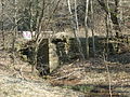
Foundation of a former building on the Sägeweiher

Alder quarry forest before the confluence with the Niederwürzbacher Weiher

Steifseggenried in the northern arm of the pond


literature
Hans Becker, Klothilde Haselmaier, Marianne Groh: The Geistkircherhof - The "Geiskerch" , in: Saarpfalz. Sheets for History and Folklore, 2000/4, Ed .: Saarpfalz-Kreis, Homburg 2000, pp. 5–55; (available as pdf: [1] (PDF; 935 kB), accessed on April 25, 2012)
Individual evidence
- ↑ GoogleEarth
- ↑ Self-measurement on the map viewer of the Saarland geoportal
- ↑ Geoportal Saarland map viewer for the Saarland ( information )
- ^ Map 1: 25,000 of the LA for Saarland maps
- ↑ a b Archive link ( Memento from February 21, 2014 in the Internet Archive )
- ^ Ordinance on the "Frohnsbachtal - Geißbachtal" nature reserve. Retrieved April 17, 2015 .
- ↑ Nature reserves in the Saarpfalz district. (PDF) (No longer available online.) Archived from the original on September 24, 2015 ; Retrieved April 17, 2015 . Info: The archive link was inserted automatically and has not yet been checked. Please check the original and archive link according to the instructions and then remove this notice.