
Watchtower (Inveraray Castle)


The watchtower of Inveraray Castle is a former watchtower near the Scottish town of Inveraray . It is on the grounds of Inveraray Castle on Dun na Cuaiche above Loch Fyne .
The watchtower was one of the buildings at Inveraray Castle that the architect Roger Morris planned in the 1740s. William Douglas acted as the head stonemason of the structure, which was completed in 1748 . In the 1960s, the tower was in poor condition after being struck by lightning. In 1971 he was included in the Scottish List of Monuments in the highest category A.
Word origin
The Gaelic name Dun na Cuaiche means Napfberg or Schüsselberg . Presumably it refers to the bowl-shaped depression at the summit. This can either have been created during the excavations for the construction of the tower or much earlier, in the early Iron Age .
Description of the tower
The one-story tower is built from quarry stone into the slope and has a cellar. It has a square floor plan, an entrance opening and, with two paneless pointed arch windows, also neo-Gothic elements. The tower ends with a stepped pyramid. Stone floors can be found in the interior.
Directions
From the parking lot of the castle, a 2.5 km long hiking trail leads up to the summit of Dun na Cuaiche and the watchtower. Follow the blue markings along the road. This initially stretches a bit between beech hedges. On the right hand side you can see a Lebanon cedar with branches protruding to the side. It is believed that the tree was planted on the occasion of Queen Victoria's visit in 1875. On the left you pass a memorial from 1754. It stood in the garden at the branch of the Bank of Scotland in Inveraray and commemorates the execution of 17 members of the Campbell clan by John Stewart, 1st Earl of Atholl .
The street crosses the Aray via the Garden Bridge . Then the path branches off to the right as a forest path into an old pine forest , a coniferous grove . Scotland has only three native conifers: the Scots pine , the yew and the juniper . English landowners in the 18th and 19th centuries were fascinated by the variety of conifers around the world and planted such groves on their property.
After a few minutes of climbing you will reach the ruins of a lime kiln . It is believed that it was in operation until around 1912. The castle administration asks not to enter the ruins.
A little above this, the path joins a farm path that leads along the western flank facing away from Loch Fyne up the mountain to the summit at 348 meters above sea level.

Garden Bridge

Old lime distillery
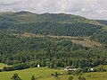
View from the ascent in west direction

View from the summit over Loch Fyne and Inveraray


Individual evidence
- ^ Dun na Cuaiche, Inveraray , web site at Walkhighlands.co.uk, accessed December 10, 2013
- ↑ Entry on Dun na Cuaiche Tower in Canmore, the database of Historic Environment Scotland (English)
- ↑ a b Listed Building - Entry . In: Historic Scotland .
- ↑ a b c d e Walking Routes on the Argyll Estate ( Memento of the original dated December 12, 2013 in the Internet Archive ) Info: The archive link was inserted automatically and has not yet been checked. Please check the original and archive link according to the instructions and then remove this notice. , Inveraray Castle website , accessed December 10, 2013
Web links
- Entry on Dun na Cuaiche Tower in Canmore, Historic Environment Scotland database
Coordinates: 56 ° 14 '44.2 " N , 5 ° 4' 2.8" W.