Walsdorf (Tandel)
|
Walsdorf ( German ) Waalsdref ( lux. ) community Tandel
|
||
|---|---|---|
| Coordinates : | 49 ° 56 ′ N , 6 ° 10 ′ E | |
| Residents : | 59 (Aug 2, 2018) | |
| Postal code : | 9465 | |
|
Location of Walsdorf in Luxembourg
|
||
|
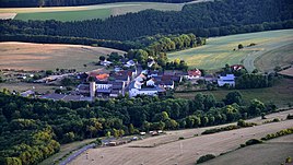
View of Walsdorf
|
||
Walsdorf ( Luxembourgish Waalsdref ) is a village in the municipality of Tandel in the canton of Vianden in Luxembourg .
location
Walsdorf is located in the Igelsbach valley, through which CR 354 runs. The village is surrounded by fields and forests, the area is quite sparsely populated. The nearest neighboring towns are Vianden and Fuhren .
General
Walsdorf is one of the smallest places in the municipality of Tandel. It is dominated by agriculture, the center of the village is the small Johanneskapelle, which belongs to the parish of Fuhren.
Web links
Commons : Walsdorf - Collection of Images
Individual evidence
- ↑ La commune en chiffres. In: Website of the municipality of Tandel. Retrieved December 27, 2018 .


