Ward, South Dakota
|
|
This article was on the basis of substantive defects quality assurance side of the project USA entered. Help bring the quality of this article to an acceptable level and take part in the discussion ! A closer description on the resolving issues is missing. |
| Ward | ||
|---|---|---|
|
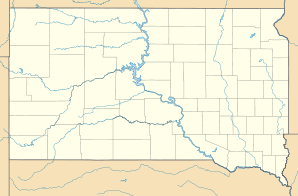
Location in South Dakota
|
||
| Basic data | ||
| State : | United States | |
| State : | South Dakota | |
| County : | Moody County | |
| Coordinates : | 44 ° 9 ′ N , 96 ° 28 ′ W | |
| Time zone : | Central ( UTC − 6 / −5 ) | |
| Residents : | 41 (as of 2000) | |
| Population density : | 58.6 inhabitants per km 2 | |
| Area : | 0.7 km 2 (approx. 0 mi 2 ) of which 0.7 km 2 (approx. 0 mi 2 ) is land |
|
| Height : | 535 m | |
| Area code : | +1 605 | |
| FIPS : | 46-68660 | |
| GNIS ID : | 1258820 | |
Ward is the northernmost town in Moody County in the US state of South Dakota . The place had 41 inhabitants (as of 2000) on an area of 0.7 km².
location
Ward is right on the state line with Pipestone County , Minnesota . The nearest major cities are Brookings in the northwest, 25 km away, and Flandreau 20 km in the southwest. Pipestone , Minnesota to the southeast is also 12 miles away as the crow flies.
Surname
Ward was named after James A. Ward, who promoted the Dakota railroad line between 1887 and 1889.

