Washington State Route 8

|
|
|---|---|
| map | |

|
|
| Basic data | |
| Overall length: | 33.27 km 20.67 miles |
| Opening: | 1964 |
| Starting point: |
|
| End point: |
|
| Counties: | Grays Harbor County Thurston County |
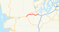
Washington State Route 8 (SR 8) is a trunk road in Grays Harbor County and Thurston County in the US state of Washington . It has a length of 20.67 miles (about 33.27 km) and connects US Highway 12 (US 12) in the City of Elma with the junction to US Highway 101 further east , about 9.5 km northwest of the capital of the state, Olympia . SR 8 crosses SR 108 west of McCleary . The road mainly serves as a connection between Elma and Olympia.
The highway was from 1937 to 1964 part of the branch line Elma - Grand Mound of the Primary State Highway 9 (PSH 9 EG), which led from Elma southeast to Interstate 5 (I-5), the former US 99 in Grand Mound , the 1967 part the US became 12. Thurston County also forms the northern limit of the Capitol State Forest .
Route description
SR 8 leads over 20.67 miles (33.27 km) from US 12 in Elma to a junction with US 101, about 9.5 km northwest of Olympia. The route only crosses another highway between Elma and Olympia, SR 108 in McCleary. The Washington Department of Traffic (WSDOT) found that at the intersection with US 101, more than 17,000 drivers use the SR 8 every day.

From its western starting point at the intersection with US 12 in Elma, SR 8 leads northeast past Downtown Elma and runs parallel to the Chehalis River . After the highway crosses the river twice, the SR 108 road crosses, which heads north to Kamilche , which is west of McCleary. Past Downtown McCleary, SR 8 passes an incomplete clover at the junction with Mox Chehalis Road, from which the freeway-like section leads east, forming the northern border of the Capitol State Forest and then past Summit Lake . From Summit Lake, the road bends northeast and joins US 101, which faces south.
history

Before the system of primary and secondary highways was introduced in 1923, SR 8 was part of the branch line of State Road 9 , from Elma to Grand Mound. In 1937 the section became part of a branch line of the Primary State Highway 9 (PSH 9 EG). PSH 9 EG became SR 8 when the highways were renumbered in Washington in 1964 ; That year the Washington State Department of Transportation (WSDOT) replaced the previous system of primary and secondary highways with the system of state routes that is still used today.
On June 20, 1967, US 12 was extended westward from Lewiston , Idaho to Aberdeen , Washington. This replaced the course of the US Highway 410 . Because US 12 used the year-round passable White Pass and SR 8 from Elma to Grand Mound, while US 410 used the Chinook Pass , which was closed in winter , bypassed US 12 both US 410 and today's SR 8. The signage was changed at the end of 1967 , and the bypassed segment of US 410 became the new SR 8.
Essential crossings
| county | location | mile | direction | annotation |
|---|---|---|---|---|
| Grays Harbor | Elma | 0.00 |
|
|
|
|
Junction; Exit westwards, entrance eastwards | |||
| McCleary | 6.03 |
|
||
| 7.39 | Mox Chehalis Road – McCleary | partial shamrock | ||
| Thurston | 20.67 |
|
Junction; Exit eastwards, entrance westwards |
supporting documents
- ↑ a b c Mark Finch: State Highway Log - Planning Report 2010. (PDF; 4.4 MB) Washington State - Department of Transport, Strategic Planning Division, 2010, pp. 1216–1223 , accessed on October 22, 2012 (English ).
- ^ Rand McNally (2008). The Road Atlas [map]. P. 108, grid square H4, H5, H6. ISBN 0-528-93961-0 .
- ^ GM Johnson (2007) (in English). Olympia, Lacey, Tumwater, Thurston County [Map], 2007, City Street Maps. Retrieved April 25, 2012.
- ↑ Washington State Department of Transportation: Washington Annual Average Daily Traffic Data ( English , PDF) 2007. Archived from the original on March 26, 2009. Retrieved April 25, 2012.
- ^ GM Johnson (2008) (in English). Port Angeles, Port Townsend, Sequim, Aberdeen, Hoquiam [map], 2008 edition, City Street Maps. Elma inset. Retrieved April 25, 2012.
- ↑ SR 8 - Emergency Slide Repair - Unstable Slope Map. Washington State Department of Transportation, 2007, archived from the original on September 30, 2012 ; accessed on September 25, 2018 (English).
- ↑ Washington State Department of Transportation (2008) (in English). Official State Highway Map (PDF), 2008–2009, 1: 842,000, Official State Highway Maps. Cartography from US Geological Survey . Grid square E2. Retrieved April 25, 2012.
- ^ Washington State Legislature: 185 . In: Session Laws of the State of Washington ( English ) (= Session Laws of the State of Washington), 1923 edition. Washington State Legislature, Olympia, Washington 1923 (Retrieved April 25, 2012).
- ↑ Washington State Legislature: 190 . In: Session Laws of the State of Washington ( English ) (= Session Laws of the State of Washington), 1937 edition. Washington State Legislature, Olympia, Washington 1937 (Retrieved October 19, 2008).
- ^ CG Prahl, Washington State Highway Commission : Identification of State Highways, Part 1 ( English , PDF; 681 kB) December 1, 1965. Retrieved April 25, 2012.
- ^ CG Prahl, Washington State Highway Commission: Identification of State Highways, Part 2 ( English , PDF; 1.1 MB) December 1, 1965. Retrieved April 25, 2012.
- ↑ a b Richard F. Weingroff: US 12 Michigan to Washington ( English ) Federal Highway Administration . May 7, 2005. Retrieved April 25, 2012.
- ↑ All-Weather Map Picked By Highway Commission (English) . In: Walla Walla Union-Bulletin , April 23, 1967, p. 5.
- ↑ Highway 410 is now US No. 12 (English) . In: Walla Walla Union Bulletin , December 28, 1967, p. 1.
- ^ UB Action Line . In: Walla Walla Union-Bulletin , September 29, 1968, p. 1.
- ↑ Washington State Highway Commission : Annual Traffic Report ( English , PDF) 1970. Archived from the original on June 25, 2008. Accessed April 25, 2012th
