Water of Leith
| Water of Leith | ||
|
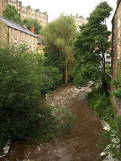
In Dean Village northwest of Edinburgh city center |
||
| Data | ||
| location | Scotland , United Kingdom | |
| River system | Water of Leith | |
| origin | Pentland Hills 55 ° 47 ′ 45 ″ N , 3 ° 28 ′ 8 ″ W. |
|
| Source height | approx. 390 m ASL | |
| muzzle | in the port of Leith in the Firth of Forth ( North Sea ) coordinates: 55 ° 59 ′ 21 ″ N , 3 ° 10 ′ 58 ″ W 55 ° 59 ′ 21 ″ N , 3 ° 10 ′ 58 ″ W |
|
| Mouth height | 0 m ASL | |
| Height difference | approx. 390 m | |
| Bottom slope | approx. 13 ‰ | |
| length | 29 km | |
| Reservoirs flowed through | Harperrig Reservoir | |
| Big cities | Edinburgh | |
The Water of Leith ( Scottish Gaelic Uisge Lìte ) is the main river of Edinburgh , Scotland . Its source is on the slopes of the Pentland Hills in West Lothian above the Harperrig Reservoir dam through which it flows. Then it meanders through the whole of Edinburgh from the suburb of Balerno in the south-west to the port of Leith in the north-east of the city, where it flows into the Firth of Forth after 29 km . Its catchment area covers 117 km² .
Web links
Commons : Water of Leith - collection of images, videos and audio files
- Website of the Water of Leith Conservation Trust
Individual evidence
- ^ Scottish Places: Water of Leith
