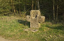
White Cross (Forst Tennenlohe)
The White Cross , also called Hirschlecke , is a historic stone cross in the non-parish area of Forst Tennenlohe in the Central Franconian district of Erlangen-Höchstadt .
Location
The stone cross is located in the White Cross forest department named after him on the so-called Heuweg in the middle of the Tennenloher Forest nature reserve in the Sebalder Reichswald . In the immediate vicinity are the enclosure for the Przewalski horses and the bullet barrier of the former military training area near Tennenlohe, which is now used as a lookout point .
description
The approximately 1.10 meter high White Cross consists of the castle sandstone that occurs in the area . The maximum width of the Latin cross is approximately 1.15 meters with a thickness of around 30 centimeters. On the front there is a conspicuous niche in the headboard as well as partly badly weathered letters, which in a description from the 1940s were clearly interpreted as "JH" on the left arm and "M" on the right arm. Numerous letters, initials , names and a heart are carved on the back . Except for the latter, it is probably a recent date. In front of the stone cross there is a stone trough almost 60 cm wide .
history
The meaning of the stone cross, which is probably from the late Middle Ages, is unknown. It may be a weather or votive cross that was erected by workers from the numerous stone quarries in the Reichswald at that time. A figure of a saint could once have stood in the niche on the headboard . The trough presumably served as a salt lick for the red deer, which was once abundant in the Nuremberg Reichswald . This is also reminiscent of the name Hirschlecke , which is also used for the White Cross , but which can lead to confusion with the source of the same name in the Buckenhofer Forest .
The current location of the stone cross does not correspond to the original location of the installation. At first it was about 590 meters further east at a no longer existing intersection of two forest paths ( coordinates ). In 1935, the Reichswehr built a military training area there. In order to protect the cross from damage or complete destruction, it was relocated for the first time in October 1941 on the initiative of the Research Foundation for German Stone Cross Research . When the military training area was later used by the US Army , the memorial was repositioned. After the troops withdrew in 1993 and the military use of the site ended, the White Cross was erected at its current location.
See also
literature
- Franz Zettler: The stone cross . The land monuments of the district of Erlangen. In: Mitteilungs-Blätter of the German Stone Cross Research . No. 1/2 , 1942, p. 32, 42 .
Web links
Coordinates: 49 ° 33 '30.7 " N , 11 ° 3' 17.3" E


