Weißiger Dorfbach
| Weißiger Dorfbach | ||
|
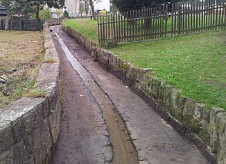
Quarry stone ditch between the main and south streets |
||
| Data | ||
| Water code | DE : 5371962 | |
| location | Saxony ( Germany ) | |
| River system | Elbe | |
| Drain over | Prießnitz → Elbe → North Sea | |
| source | south of Weißig 51 ° 2 ′ 57 ″ N , 13 ° 54 ′ 30 ″ E |
|
| muzzle | near the Ullersdorfer mill in the Prießnitz Coordinates: 51 ° 4 ′ 19 ″ N , 13 ° 53 ′ 5 ″ E 51 ° 4 ′ 19 ″ N , 13 ° 53 ′ 5 ″ E
|
|
| length | approx. 3.7 km | |
| Left tributaries | Weidenbach, Dammbach |
|
| Right tributaries | Strauchgraben, Kutscherbach |
|
| Flowing lakes | Shrub pond , white village pond |
|
| Communities | Whitish | |
The Weißiger Dorfbach is about 3.7 kilometers long, left tributary of the Prießnitz in the Dresden district of Weißig in the village of Schönfeld-Weißig .
course
The Weißiger Dorfbach rises southeast of the village. After it has absorbed the water from the shrub ditch and crossed the shrub pond, it flows through the village of Altweißig, where the river bed runs in places through a monument-protected ditch bordered with rubble stones. In Altweißig the village stream takes the water of the willow and dam stream and feeds the white village pond. North of federal highway 6 , the Kutscherbach flows into the Weißiger Dorfbach, which then flows into the Prießnitz on the southern edge of the Dresdner Heide , not far from the Ullersdorfer Mühle .
When a new residential area was built in the north of Weißig after the fall of the Wall , one of the streets laid out for this was named Am Weißiger Bach .
Flood protection
During the floods of 2002 , there was considerable damage from flooding in the area of the Weißiger Dorfbach, especially in the hollow of the Altweißig location. As a result, as part of the flood damage remediation measures, it was decided to partially expose the village stream and make it close to nature, and the construction of a flood retention basin was also initiated. Between January and July 2009, in cooperation with the Dresden Environment Agency, a “green” retention basin containing 16,500 cubic meters of water was created on the Dorfbach in Altweißig. In September 2009, it was officially inaugurated by the then First Mayor of Dresden, Dirk Hilbert . In 2010, another retention basin was added in the area of the dam brook. During the flood event in 2013 , the retention basin of the Weißiger Dorfbach was partially flooded for the first time since its completion.
Web links
Individual evidence
- ↑ Surface waters with springs. (PDF; 367 KB) In: Environmental Atlas Dresden. State capital Dresden, Environment Agency, November 2015, accessed on July 1, 2016 .
- ^ Lars Herrmann: Streets and squares in Weißig. In: www.dresdner-stadtteile.de. Retrieved July 1, 2016 .
- ↑ Weißiger Dorfbach flood retention basin is completed. State capital Dresden, September 7, 2009, accessed on July 1, 2016 .
- ↑ Heiko Weckbrodt: Flood protection will keep Dresden busy for years. Dresden Latest News, June 7, 2016, accessed July 1, 2016 .
- ^ State capital Dresden (ed.): Environmental report 2013 - Report on the June floods in Dresden. Annex 1: Floods on the second-order waters in Dresden from June 1st to 3rd, 2013 and subsequent heavy rain events on June 9th, 2013, June 20th to 21st. June 2013 and 25-26 June 2013, p. 43.
