Weimarskamp
|
Weimarskamp
Municipality Westhausen
Coordinates: 51 ° 23 ′ 12 ″ N , 10 ° 12 ′ 19 ″ E
|
|
|---|---|
| Height : | approx. 305 m above sea level NN |
| Postal code : | 37308 |
| Area code : | 03606 |
|
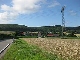
Weimarskamp at the foot of the Dün
|
|
Weimarskamp is a hamlet in the Bodenrode-Westhausen community in the Eichsfeld district in Thuringia .
location
The settlement is within the district of Bodenrode at the foot of the Dün about four kilometers east of Heilbad Heiligenstadt , directly at the intersection of the state roads L 3080 and L 2020 . The Springbach rises to the south and flows into the Leine in Westhausen . About half a kilometer to the west is the Hunrode desert .
history
The name is said to have originated during the Thirty Years War when soldiers of Duke Wilhelm von Weimar camped here. The first buildings were later built on the old road. In the middle of the 19th century, the Gasthaus Zur Recreation was built, which became so well known in the area that the place is still commonly called recovery today. Until recently, the main source of income for the residents was agriculture.
Individual evidence
- ↑ Volker Große and Klaus Herzberg: Weimarskamp-A settlement on the B 80 near Bodenrode Eichsfelder Heimatzeitschrift 53rd year 2009, issue 2, pp. 47-49
