Wells Saddle
| Wells Saddle ( mountain saddle ) |
|||
|---|---|---|---|
|
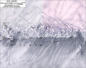
Topographic map (1: 250,000) of the Flood Range with the Wells Saddle (left of center) |
|||
| Compass direction | north | south | |
| Marie Byrd Land , West Antarctica | |||
| Mountains | Flood range | ||
| map | |||
|
|
|||
| Coordinates | 76 ° 3 ′ 0 ″ S , 135 ° 35 ′ 0 ″ W | ||
The Wells Saddle is a wide and snow-covered mountain saddle in Marie-Byrd Land in West Antarctica . In the Flood Range it is between Mount Berlin and Mount Moulton .
The first aerial photographs were taken in 1940 during the United States Antarctic Service Expedition (1939–1941). The United States Geological Survey mapped it using its own surveys and aerial photographs of the United States Navy from 1959 to 1966. The Advisory Committee on Antarctic Names named the saddle in 1974 after James H. Wells, a member of the team that worked between 1971 and 1972 as part of the United States Antarctic Research Program had investigated the movement dynamics of the Antarctic ice sheet in the area northeast of Byrd Station .
Web links
- Wells Saddle in the Geographic Names Information System of the United States Geological Survey (English)
- Wells Saddle on geographic.org (English)

