Wenden (Ebhausen)
|
Turn
community Ebhausen
Coordinates: 48 ° 37 ′ 24 ″ N , 8 ° 39 ′ 41 ″ E
|
||
|---|---|---|
| Area : | 3.68 km² | |
| Residents : | 224 (2014) | |
| Population density : | 61 inhabitants / km² | |
| Incorporation : | 1st January 1975 | |
| Postal code : | 72224 | |
| Area code : | 07458 | |
|
Location of Wenden in Baden-Württemberg |
||
|
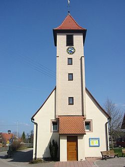
Evangelical Church in Wenden
|
||
Wenden is a village in the northern Black Forest and is the smallest of the four districts of the Ebhausen community .
geography
The district area covers 368 hectares and is predominantly characterized by red sandstone . Around 200 hectares are forested. Wenden is between 537 and 610 meters above sea level.
Worth seeing
The small church has a tower clad with wooden shingles, which makes the church unique in the area. The historical bakery next door is also inviting for a tour.
history
The place was first mentioned in a document in 1406. The spelling “Winden” or “Wynna” was also used in earlier times. The name suggests a possible foundation in the Carolingian period when Charlemagne had settled the Slavic Wends in other parts of his empire.
In the course of the community reform on January 1, 1975, the previously independent community of Wenden was combined with Ebershardt , Rotfelden and Ebhausen to form the entire community of Ebhausen.
Population development
- 1862: 185 inhabitants
- 2000: 228 inhabitants
- 2001: 233 inhabitants
- 2002: 233 inhabitants
- 2003: 242 inhabitants
- 2004: 238 inhabitants
- 2014: 224 inhabitants
See also
Individual evidence
- ^ Federal Statistical Office (ed.): Historical municipality directory for the Federal Republic of Germany. Name, border and key number changes in municipalities, counties and administrative districts from May 27, 1970 to December 31, 1982 . W. Kohlhammer, Stuttgart / Mainz 1983, ISBN 3-17-003263-1 , p. 489 .


