
Wignacourt Aqueduct

The Wignacourt Aqueduct ( Maltese Akwadott ta 'Wignacourt , English Wignacourt Aqueduct ) is an aqueduct on the island of Malta . It was built between 1610 and 1614 by the Order of Malta under the rule of the Grand Master Alof de Wignacourt and led from Mdina to Valletta . The best preserved routes are in Birkirkara , Santa Venera and Mrieħel .
Location and surroundings
The porous globigerines - limestone from which the islands of the Maltese archipelago consist, can quickly seep rainfall, rivers or lakes, there is therefore no. In damp winters the Wieds (Maltese name for dry valleys ) carry water for some time.
Under the Mdina plateau, however, there is a layer of impermeable, so-called blue clays between the limestone layers . The fresh water resources above the clay layer are relatively easily accessible. The aqueduct was fed from this water-bearing layer.
The aqueduct stretched over a length of about 16 km and carried fresh water from Mdina via Attard , Balzan , Birkirkara, Santa Venera and Mrieħel to Valletta. Most of the route was built above ground. The aqueduct leads over stone arches, the height and diameter of which change depending on the terrain .
description
The course in Attard shows a series of relatively small stone arches that ensure an even gradient for the flow of water.
In Balzan, which, like Attard, is higher up, the arches of the aqueduct are only low in height, because here the water could flow almost unhindered. The higher the landscape relief, the lower the arches can be; conversely, valleys must be spanned with high arches. Therefore, the aqueduct in Balzan is largely massive, this only changes at the municipal boundary to Birkirkara.
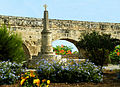
In Birkirkara, the arches of the aqueduct are medium-sized compared to the rest of the route.
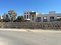
The underground section of the aqueduct begins in Santa Venera. Inspection towers, in which the water quality could be examined, can be found in Santa Venera, Ħamrun ( water tower in Ħamrun ) and Floriana .
history
History of origin
After the siege of Malta by the Turks in 1565, it became clear that the strategically located port of Valletta had no natural water sources. Alof de Wignacourt, Grand Master of the Order of Malta from 1601 to 1622, provided the necessary funds of 400,000 scudi in 1610 to realize the plan for an aqueduct developed by his predecessor Martin Garzes in 1596. This was built between 1610 and 1614 under the direction of master builders Giovanni Attard and Bontadino de Bontadini and inaugurated on April 21, 1615. It supplied four main cisterns in the city, from which other water reservoirs were fed. In addition, fountains were built in the city, for example the fountain at St. James Cavalier in Valletta in 1615.
History of the structure
After Malta became a British colony in 1802 , a second line from the Fawwara plateau was put into operation in 1845 , which supplied the east of Malta.
The aqueduct was in operation well into the 20th century. It was restored in 2007.

Small arches in Attard

Single arch in Balzan
The aqueduct on the municipal boundary between Balzan and Birkirkara

Arches in Santa Venera

Water tower in Ħamrun
In Mrieħel there are remains of the aqueduct in front of the Farsons brewery .


Individual evidence
- ↑ a b Akwadott ta 'Wignacourt / Wignacourt Aqueduct. (PDF) In: National Inventory of the Cultural Property of the Maltese Islands. Sovrintendenza tal-Patrimonju Kulturale, December 28, 2012, accessed October 25, 2019 (English, No. 1229).
- ↑ Akwadott ta 'Wignacourt / Wignacourt Aqueduct. (PDF) In: National Inventory of the Cultural Property of the Maltese Islands. Sovrintendenza tal-Patrimonju Kulturale, December 28, 2012, accessed October 25, 2019 (English, no.1153).
- ↑ Akwadott ta 'Wignacourt / Wignacourt Aqueduct. (PDF) In: National Inventory of the Cultural Property of the Maltese Islands. Sovrintendenza tal-Patrimonju Kulturale, December 28, 2012, accessed October 25, 2019 (English, no. 1165).
- ↑ a b Wignacourt Aqueduct and Towers
- ↑ Michael Ellul: Wignacourt aqueduct. Times of Malta , February 3, 2007, accessed October 25, 2019
Coordinates: 35 ° 53 ′ 35 ″ N , 14 ° 27 ′ 39 ″ E