Wilder Graben (Ilm)
|
Wilder Graben lower reaches: trenches |
||
|
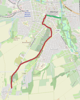
Course of the Wild Trench from the source in Gelmeroda to Weimar (red) and further course as a trench (green) to the confluence with the Ilm |
||
| Data | ||
| location | Weimar , Thuringia | |
| River system | Elbe | |
| Drain over | Ilm (Saale) → Saale → Elbe → North Sea | |
| source |
Gelmeroda 50 ° 57 ′ 9 " N , 11 ° 18 ′ 16" E |
|
| muzzle | from the left in Weimar to the Ilm Coordinates: 50 ° 58 ′ 41 ″ N , 11 ° 20 ′ 0 ″ E 50 ° 58 ′ 41 ″ N , 11 ° 20 ′ 0 ″ E
|
|
| Right tributaries | Lohgraben | |
| Medium-sized cities | Weimar | |
| Communities | Gelmeroda | |
The Wilde Graben is a left tributary of the Ilm in Weimar . It rises in Gelmeroda and flows into the Ilm in the park on the Ilm. Its natural course probably led it into the Lottenbach , which at that time still flowed through the old town of Weimar, but it was already led past the old town as a trench as a trench in the Middle Ages . The Wilde Graben is only occasionally water-bearing, but with heavy rainfall it can absorb enormous torrential amounts of water, which is where its name comes from
Today's course
The Wilde Graben rises in Gelmeroda under an artificial hill that is maintained by the water management. It is canalised from there to under Rudolstädter Straße and then runs openly parallel to the An der Chaussee street in a forest to the north. It then flows to the east near Berkaer Strasse , where it is pitted by the Lohgraben and an unnamed stream. Then it runs north between the Historic Cemetery Weimar and Berkaer Straße . From Berkaer Straße at the corner of Karl-Hausknecht-Straße , the Wilde Graben is canalised throughout the city and runs along Berkaer Straße , Rudolf-Breitscheid-Straße , Am Poseckschen Garten , Trierer Straße , Prellerstraße , Steubenstraße , Gropiusstraße. At Sophienstiftsplatz it then becomes a trenches and runs under Hummelstrasse and further under Schillerstrasse and Puschkinstrasse and then flows into these in Park on the Ilm.
history
While the Wilde Graben in the Gelmeroda area to the Weimar Historic Cemetery largely follows its historical and open course, apart from a few sewer systems due to intersecting streets, the creek is canalised throughout the city of Weimar. Presumably, the Wilde Graben did not previously run from today's Sophienstiftsplatz to the east as a trench, but instead flowed into the Lottenbach , which had its historical course to the northeast along the Wittumspalais , Marktstrasse , Schlossgasse , Kegelplatz and there it flowed into the Ilm north of the Weimar City Palace . The trench was created in the Middle Ages to avoid the destruction in the urban area by the flood phases of the Wilder Graben. This also ended the confluence of the Wilder Graben with the Lottenbach at today's Sophienstiftsplatz . However, at the end of the 18th century and possibly even earlier there was a relief system with which the Lottenbach could be drained into the trenches in the event of heavy rainfall in order to relieve the urban Lotten canals and to avoid flooding in the city. It is not entirely clear whether this is a permanent drain, an abundance or a controllable drain.
The trench was vaulted from 1824 at the request of Carl August von Sachsen-Weimar-Eisenach . These construction measures were initially taken over by Clemens Wenzeslaus Coudray . Ultimately, however, it was not until 1880 that the vaulting of the trenches was completed on the last piece , which was called duck catching before the vaulting (at today's Sophienstiftsplatz , Hummelstraße ).
literature
Axel Stefek: Weimar underground. The Lottenbach and the trenches as historical city waters . In: Weimar - Jena: The big city 4/4 . Verlag Vopelius, 2011, p. 241–261 ( PDF (1.3 MB) ).
Web links
Individual evidence
- ^ A b Axel Stefek: Weimar underground. The Lottenbach and the trenches as historical city waters . In: Weimar - Jena. The big city 4/4 . Verlag Vopelius, 2011, p. 241-261 .
- ↑ Sophienstiftsplatz Weimar - Architectural studies. Accessed February 1, 2020 .


