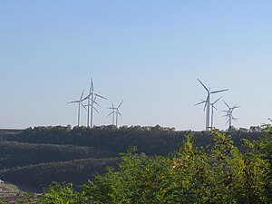
Kaiskorb wind farm
| Kaiskorb wind farm | |||
|---|---|---|---|
| Kaiskorb wind farm seen from the north | |||
| location | |||
|
|
|||
| Coordinates | 51 ° 1 '42 " N , 6 ° 29' 32" E | ||
| country |
|
||
| Data | |||
| Type | Wind farm | ||
| Primary energy | Wind energy | ||
| power | 26.05 MW | ||
| operator | ABO Wind AG BMR energy solutions GmbH |
||
| Start of operations | 2006, 2016 | ||
| turbine |
Vestas V80-2MW (12 ×) Senvion MM92 (1 ×) |
||
| was standing | July 2020 | ||
The Kaiskorb wind farm is located in the northern urban area of Bedburg in North Rhine-Westphalia , directly on the federal motorway 61 , and consists of 13 wind turbines .
location
The wind farm is located on the edge of the urban area of Bedburg in the Rhein-Erft district , in the Kirchherten district . The municipality of Titz with the district Jackerath is located some distance to the northwest. West of the park on the other side of the BAB 61 is the eponymous Gut Kaiskorb . The Garzweiler open-cast lignite mine , with its active part to the north, is also in the immediate vicinity; a part of the open-cast mine that has meanwhile been filled in bordered the park directly to the north and east.
To the west of the wind farm runs the federal highway 61 and to the north the new federal highway 44, which opened in 2018 . The Jackerath motorway junction , where the two motorways intersect, borders the site to the northwest. To the southeast of the wind farm is the site of a disused NATO launching area for the Belgian air force , where nuclear missiles were also stored from 1963 to 1989.
history
The area was designated in 2002 by the city of Bedburg as a concentration zone for wind power. In 2006, the project developer ABO Wind installed twelve Vestas V80-2MW wind turbines from the Danish manufacturer Vestas . Although the infrastructure was completed at the end of 2005, the systems could not be built until the beginning of 2006 due to the manufacturer's delivery bottlenecks. All systems have a nominal output of two megawatts with a hub height of 100 m and a rotor diameter of 80 m.
The systems are arranged in two rows of six systems each parallel to the BAB 61. At the time of construction, the area to the northeast was still the mining zone of the Garzweiler I opencast mine. This was backfilled by around 2015, so that an expansion of the wind farm to the east would be conceivable. In 2014 and 2015, the Königshovener Höhe wind farm, the second wind farm in the city of Bedburg, was built on an area that had already been filled a few years earlier .
A thirteenth wind turbine was built in 2016 on the northwestern edge of the wind farm site. This Senvion MM92 system from the German manufacturer Senvion was planned and built by BMR energy solutions GmbH from Geilenkirchen . This plant, which went into operation in August 2016, also has a hub height of 100 m, but a larger rotor diameter of 92 m and a nominal output of 2.05 MW.
Web links
Individual evidence
- ↑ Atomwaffen A – Z: Bedburg. Retrieved July 7, 2020 .
- ^ City of Bedburg: 51st zoning plan amendment - expansion of the Königshoven wind farm. (pdf) Accessed July 7, 2020 .
- ↑ Windbranche.de: ABO Wind with very good annual results - dividend proposed. Retrieved July 21, 2020 .
- ↑ BMR energy solutions: References wind energy June 2020. Accessed on July 21, 2020 .


