Witznautalsperre
| Witznautalsperre | |||||||
|---|---|---|---|---|---|---|---|
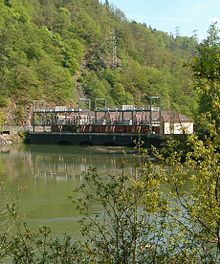
| The Witznau reservoir in the Schwarza valley | |||||||
|
|||||||
|
|
|||||||
| Coordinates | 47 ° 41 ′ 18 ″ N , 8 ° 15 ′ 5 ″ E | ||||||
| Data on the structure | |||||||
| Construction time: | 1939-1943 | ||||||
| Height above valley floor: | 36.50 m | ||||||
| Height above foundation level : | 49.35 m | ||||||
| Height of the structure crown: | 476 m | ||||||
| Building volume: | 63 600 m³ | ||||||
| Crown length: | 116 m | ||||||
| Crown width: | 6.2 m | ||||||
| Data on the reservoir | |||||||
| Altitude (at congestion destination ) | 474.5 m | ||||||
| Water surface | 14 ha | ||||||
| Storage space | 1.42 million m³ | ||||||
| Total storage space : | 1.42 million m³ | ||||||
| Catchment area | 92.57 km² | ||||||
| Design flood : | 240 m³ / s | ||||||
The Witznautalsperre or the Witznau reservoir ( Witznaubecken ) is a pumped storage reservoir in the Schwarza valley near Witznau , municipality of Ühlingen-Birkendorf , in the southern Black Forest .
geography
The Witznau reservoir is located in the Schwarza valley about 1.25 km above the eponymous town of Witznau or the confluence with the Schlucht (see above for coordinates) at about 475 m above sea level. NN. The power plant and the reservoir are in the area of the communities of Weilheim and Ühlingen-Birkendorf . Immediately to the east on the ridge is the village of Berau , municipality of Ühlingen-Birkendorf, with the moated castle belonging to the pumped storage facility .
District road 6561 runs along the reservoir, from which a municipal road leads to the ridge in the west to Nöggenschwiel , Weilheim municipality.
function
The Witznau reservoir is the lower basin of the Witznau pumped storage plant operated by Schluchseewerke AG between the Schluchsee and the Upper Rhine .
The dam takes over the function of the lower basin for the intermediate level , the Witznau pumped storage power plant with the Schwarzabruck reservoir as the upper basin .
At the same time, it is for the lower level , the Waldshut power plant , the upper basin with the Rhine as a natural lower basin (backwater area of the river power plant Rheinkraftwerk Albbruck-Dogern AG ( RADAG )).
The upper level is formed by the Schluchsee (upper basin) together with the Schwarzabruck reservoir (lower basin).
The Witznau reservoir is also supplied with water by a weir on the Schlucht near the Mettma estuary.
technical features
The Witznau power plant is the middle level of the three levels and has the greatest drop of 250 m. Its expansion capacity is 220 MW turbine output and 128 MW pump output .
The barrier structure is a concrete gravity dam . The power station building has been placed on the wall.
history
The construction of the dam lasted from 1939 to 1943, when the power plant with the first machine set was put into operation. Construction work was interrupted due to the war. The power station with a total of four machines was not fully commissioned until 1950.
literature
- Peter Franke, Wolfgang Frey: Dams in the Federal Republic of Germany. Systemdruck, Berlin 1987, ISBN 3-926520-00-0 .


