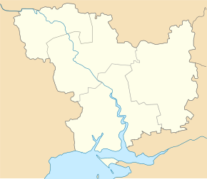
Volodymyrivka (Kazanka)
| Volodymyrivka | ||
| Володимирівка | ||

|
|
|
| Basic data | ||
|---|---|---|
| Oblast : | Mykolaiv Oblast | |
| Rajon : | Kazanka District | |
| Height : | 49 m | |
| Area : | 4.186 km² | |
| Residents : | 2,793 (2001) | |
| Population density : | 667 inhabitants per km² | |
| Postcodes : | 56065 | |
| Area code : | +380 5164 | |
| Geographic location : | 47 ° 31 ' N , 32 ° 56' E | |
| KOATUU : | 4823681401 | |
| Administrative structure : | 2 villages, 1 settlement | |
| Address: | вул. Радянська 91 56065 с. Володимирівка |
|
| Statistical information | ||
|
|
||
Volodymyriwka ( Ukrainian Володимирівка ; Russian Владимировка Wladimirowka ) is a village in the east of the Ukrainian Oblast Mykolaiv with about 2800 inhabitants (2001).
The village, founded in 1810, is located on the banks of the Vysun and is the administrative center of the district council of the same name in the south of Kazanka Rajon , which also includes the village Novosillja ( Новосілля ⊙ ) with about 110 inhabitants and the settlement Lisowe ( Лісове ⊙ ) with about 100 inhabitants .
Volodymyrivka is 40 km south of the district capital Kazanka and about 125 km northeast of the center of Mykolaiv Oblast . To the west of Volodymyrivka runs the territorial road T – 15–12 .
Web links
Commons : Volodymyriwka - collection of pictures, videos and audio files
Individual evidence
- ^ Website of the village on the official website of the Verkhovna Rada , accessed on July 7, 2017


