Worbarrow Tout
| Worbarrow Tout | ||
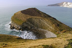
 Pondfield Cove and Worbarrow Tout |
||
| Geographical location | ||
|
|
||
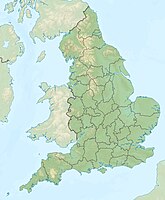
| Coordinates | 50 ° 36 '56 " N , 2 ° 11' 7" W | |
| Waters 1 | English Channel | |
Worbarrow Tout is a headland at the eastern end of Worbarrow Bay east of Lulworth Cove on the peninsula Isle of Purbeck in the county of Dorset , on the English Channel coast of England .
location
Worbarrow Bay is about six kilometers south of Wareham and about 16 kilometers west of Swanage .
The conical hill of Worbarrow Tout was originally part of Gad Cliff to the east but is now separated by the small bay of Pondfield Cove . Worbarrow Bay and Worbarrow Tout are part of the Jurassic Coast .
geology
Worbarrow Bay was formed in the Cretaceous Period , about 145 to 90 million years ago. The bay's cliffs contain layers of Upper Cretaceous , Middle Cretaceous , Greensands , Gault , Wealden Beds , Purbeck, and Portland . Due to the effects of the Purbeck monocline , the rocks formed are complexly folded, with all sediments inclined vertically by about 45 degrees.
The cliff sediments were also rotated horizontally. This is why the chalk is found on the back of the bay while the Portland Stone and Purbeck Beds make up the front. Worbarrow Tout is made up of the 150,000,000 year old Portland limestone and the 147,000,000 year old Purbeck beds.
Worbarrow Tout is pointed in shape and the steep angles of the rock layers clearly show the complex folding in this area. The whole thing was caused by the tectonic pressure when the continents Africa and Europe collided around 30 million years ago and formed the Alpine mountain range at that time.
