Gad Cliff
| Gad Cliff | ||
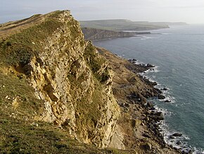
 Gad Cliff on the south coast of the Isle of Purbeck |
||
| Geographical location | ||
|
|
||
| Coordinates | 50 ° 36 '55 " N , 2 ° 10' 7" W | |
| Waters 1 | English Channel | |
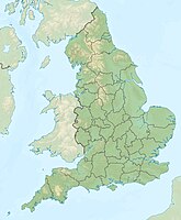
Gad Cliff is a south-facing partially eroded cliff on the English Channel - Coast between Worbarrow Bay and Kimmeridge on the peninsula Isle of Purbeck , in the county of Dorset , in England .
location
Gad Cliff is about one kilometer south of the ghost village of Tyneham and about six kilometers south of Wareham . Gad Cliff is about eight miles east of Swanage .
The highest point of Gad Cliff is approximately 134 meters above sea level. The westernmost part of the rock face is known as Gold Down . Wagon Rock is a large boulder that fell out of the top of the cliff.
Access to Gad Cliff is only possible when the Lulworth Military Range is open to the public. Gad Cliff is only accessible on foot, either via the coastal path or from Tyneham car park . The property is owned by the UK Department of Defense and forms part of the Armored Fighting Vehicles Gunnery School. The wall paths and the coastal path are open on weekends. Visitors are warned to stay on the footpaths, which are cleared by duds.
Jurassic Coast
The coast and cliffs along the English Channel coast in East Devon and Dorset are some of the most outstanding natural landmarks in the world. From Orcombe Point to Old Harry Rocks there is a 155 kilometer stretch of coastline, which was the first natural landscape in England to be declared a UNESCO World Heritage Site.
The rock strata along the coast slope slightly to the east. Therefore, the oldest part is in the western area, progressively younger rocks form the cliffs further east. The natural revelations along the rock walls reveal a continuous sequence of geological deposits formed in the Triassic , Jurassic and Cretaceous periods and represent around 185 million years of geological history . The cliffs of Gold Down and Gad Cliff, as well as Wagon Rock are part of the so-called Jurassic Coast .
geology

The geology of the Isle of Purbeck is very complex and this is shown very clearly in this stretch of coast. Due to the effects of the Purbeck monocline , the rock layers formed are complexly folded. The whole thing was caused around 30 million years ago by tectonic pressure when the continents of Africa and Europe collided and formed the Alpine mountain range. At Gad Cliff, the sediments slope between 25 and 35 degrees inland. As a result of the earth moving, the uppermost layers are bent into the shape of a giant S.
There are four shift sequences along Gad Cliff. The topmost layers are the Purbeck Beds , which were formed about 147 million years ago, and the Portland Limestones , about 150 million years old. These are above a Portland Sands bench . The underlying calcareous clay mineral 'Kimmeridge Clay' was formed about 155 million years ago. The upper layer of the Kimmeridge Clay belongs to the Kimmeridgian level sensu anglico . These layers dip about 10 to 20 degrees to the north.
The shallow ridge below the cliffs is named Long Ebb Reef. From there to the northwest, the following rock layers are present: Washing Ledge ( dolomite ), Maple Ledge (also dolomite), Cattle Ledge, Gray Ledge, Blackstone ( oil shale ) and White Stone Band ( coccolith ).
Due to the fact that the harder limestone and sandstones are underlain by an unstable clay mineral, Gad Cliff is prone to landslides.
Individual evidence
- ↑ Safety and access restrictions: Lulworth ranges . Retrieved November 16, 2010.
- ↑ a b Dorset and East Devon Coast . UNESCO World Heritage Center. 2001. Retrieved November 16, 2010.
- ^ Geology of the Wessex Coast of Southern England . Southampton University, UK. By Ian West. 2010. Retrieved November 16, 2010.

