Wuluwati dam
| Wuluwati dam | |||||||
|---|---|---|---|---|---|---|---|
|
|||||||
|
|
|||||||
| Coordinates | 36 ° 49 '30 " N , 79 ° 27' 4" E | ||||||
| Data on the structure | |||||||
| Construction time: | 1995-2001 | ||||||
| Height of the barrier structure : | 138 m | ||||||
| Height of the structure crown: | 1965.8 m | ||||||
| Building volume: | 6.77 million m³ | ||||||
| Crown length: | 473 m | ||||||
| Power plant output: | 60 MW | ||||||
| Data on the reservoir | |||||||
| Water surface | 13 km² | ||||||
| Storage space | 347 million m³ | ||||||
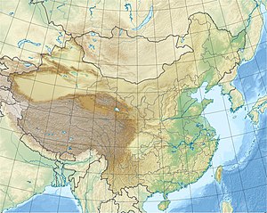
The Wuluwati Dam ( Chinese 乌鲁瓦提 水利 风景区 ) is a large dam on the Karakax River (also called Karakashi or Karakax He) in Xinjiang in the west of the People's Republic of China . It is located 71 km from the city of Hetian in the Uyghur Autonomous Region.
The reservoir is used for irrigation, electricity generation, flood protection, water supply and biological issues. It is one of the most important projects in the region ("Wuluwati Key Water Conservancy Project") and is included in China's ninth five-year plan . 75,300 hectares of land will be better irrigated and the irrigated area will be increased by 46,000 hectares.
The barrier structure is a stone embankment dam with a reinforced concrete seal on the water side, a so-called "Concrete face rockfill dam" ( CFRD ), a construction method common and common in China. In 1993 the state planning commission decided to build it. On July 2, 1994, construction of the power plant pipelines began, and in July 1995, main work on the dam began. On September 2, 1997, the river was closed.
Components of the structure include a flood relief , tunnel for sand and sediment drainage, a sluice, pressure pipes to the hydropower plant and a switching station (substation). Of the 865 million yuan construction cost, 340 million was paid by the central government, 335 million by the regional government and 190 million by companies.
See also
- List of hydropower plants in China
- List of dams in China
- List of the largest dams on earth
- List of the largest reservoirs on earth
Web links
- Wuluwati Shuili Shuniu (Chinese) ( Memento from December 21, 2013 in the Internet Archive )
- China's Key Water Control Projects
