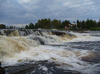
Wyg
|
Lower Wyg Нижний Выг, White Sea-Baltic Canal |
||
| Data | ||
| Water code | RU : 02020001322302000004960 | |
| location | Republic of Karelia ( Russia ) | |
| River system | Wyg | |
| origin |
Wygosero 63 ° 51 ′ 37 ″ N , 34 ° 19 ′ 45 ″ E |
|
| muzzle | near Belomorsk in Onega Bay Coordinates: 64 ° 31 '27 " N , 34 ° 46' 58" E 64 ° 31 '27 " N , 34 ° 46' 58" E |
|
| Mouth height |
0 m
|
|
| length | 188 km | |
| Catchment area | 27,100 km² | |
| Drain at the mouth |
MQ |
267 m³ / s |
| Discharge at the gauge Palakorgskaja power station A Eo : 23,600 km² Location: 44 km above the mouth |
MNQ 1967/1988 MQ 1967/1988 Mq 1967/1988 MHQ 1967/1988 |
186 m³ / s 227 m³ / s 9.6 l / (s km²) 263 m³ / s |
| Discharge at the Matko A Eo gauge : 26,500 km² Location: 21 km above the mouth |
MNQ 1956/1988 MQ 1956/1988 Mq 1956/1988 MHQ 1956/1988 |
225 m³ / s 260 m³ / s 9.8 l / (s km²) 293 m³ / s |
| Left tributaries | Onda , Tunguda , Letnjaja | |
| Reservoirs flowed through | Lake Vygozero , Matkosero , Telekinskoje | |
| Small towns | Nadwoitsy , Belomorsk | |
|
Upper Wyg Верхний Выг |
||
| Water code | RU : 02020001212102000005158 | |
| location | Republic of Karelia ( Russia ) | |
| River system | Wyg | |
| Drain over | Lower Wyg → White Sea | |
| origin | See Egosero 62 ° 38 '43 " N , 36 ° 31' 21" O |
|
| muzzle |
Wygosero 63 ° 19 ′ 12 ″ N , 35 ° 18 ′ 48 ″ E
|
|
| length | 135 km | |
| Catchment area | 3000 km² | |
| Discharge at the Woroschgora A Eo gauge : 2970 km² Location: 6 km above the mouth |
MNQ 1955/1961 MQ 1955/1961 Mq 1955/1961 MHQ 1955/1961 |
4 m³ / s 26 m³ / s 8.8 l / (s km²) 140 m³ / s |
The Wyg ( Russian Выг , Finnish Uikujoki ) is a river in the Republic of Karelia in northwestern Russia .
The river consists of two river sections:
The upper course is formed by the 135 km long Upper Wyg ( Russian Верхний Выг ), which flows into the Vygosero . It has its origin in Lake Egosero, southeast of the Vygosero . It runs in a north-westerly direction through a swamp landscape and flows through several smaller lakes.
The lower reaches of the 102 km long Lower Wyg ( Russian Нижний Выг ) formed. It drains the Vygosero to the north and flows to Onega Bay , the southwestern end of the White Sea . The Lower Wyg is regulated by several dams and locks and is part of the White Sea-Baltic Sea Canal . A large part of the water of the Vygosero leaves the reservoir via the Ondskoje hydroelectric power station and the lower reaches of the Onda and meets a few kilometers north of the actual White Sea-Baltic Sea Canal or the Lower Wyg.
The catchment area of the Wyg covers 27,100 km². The total length of the upper course, lower course and the Vygosero through which it flows is 314 km. The mean discharge at the mouth is 267 m³ / s. In the Wygosero the following rivers flow into the Wyg: Segescha , Onda and Woschma .
Individual evidence
- ↑ a b c Lower Wyg in the State Water Directory of the Russian Federation (Russian)
- ^ Article Wyg in the Great Soviet Encyclopedia (BSE) , 3rd edition 1969–1978 (Russian)
- ↑ White Sea Canal at the Palakorgskaja power station gauge - hydrographic data from R-ArcticNET
- ↑ White Sea Canal at the Matko gauge - hydrographic data from R-ArcticNET
- ↑ a b c Upper Wyg in the State Water Register of the Russian Federation (Russian)
- ↑ Upper Wyg at the Woroschgora gauge - hydrographic data from R-ArcticNET
