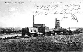
Humboldt colliery
| Humboldt colliery | |||
|---|---|---|---|
| General information about the mine | |||
| historical postcard view from 1911 | |||
| Mining technology | & | ||
| Information about the mining company | |||
| End of operation | 1929 | ||
| Successor use | Commercial space (shopping center) | ||
| Funded raw materials | |||
| Degradation of | Hard coal | ||
| Geographical location | |||
| Coordinates | 51 ° 26 '20.4 " N , 6 ° 57' 22.1" E | ||
|
|||
| Location | Be called | ||
| local community | Mülheim an der Ruhr | ||
| Independent city ( NUTS3 ) | Mülheim an der Ruhr | ||
| Federal Republic | Federal Republic of Germany | ||
| Country | Germany | ||
| District | Ruhr area | ||
The bill Humboldt was a coal - mine in Mülheim an der Ruhr , in the district hot area.
In the fields of the “Humboldt” colliery, coal was mined as early as the 18th century , and since 1855 also in civil engineering with the “Franz” shaft , which was only abandoned in 1952. In 1876 the mining trade union "Humboldt" was founded. The head of the mine was the banker Gustav Hanau . In 1898 the deficit "Humboldt" colliery was incorporated into the Mülheim Mining Association . The "Humboldt" colliery reached its highest output of 218,071 tons in 1913 with 768 employees. In 1929 the conveyor systems were shut down and dismantling was carried out by the Rosenblumendelle colliery and the Wiesche colliery , with the land sales being used for this colliery network until the end of the 1960s.
A shopping center, the RheinRuhrZentrum, has been located on the former colliery site since 1973 .
See also
literature
- Wilhelm Hermann, Gertrude Hermann: The old mines on the Ruhr. 6th edition, updated by Christiane Syré and Hans-Curt Köster. Langewiesche successor Hans Köster, Königstein im Taunus 2007, ISBN 3-7845-6994-3 .

