Zincirli
| Zincirli | ||||
|
||||
| Basic data | ||||
|---|---|---|---|---|
| Province (il) : | Gaziantep | |||
| District ( ilçe ) : | İslahiye | |||
| Coordinates : | 37 ° 6 ' N , 36 ° 41' E | |||
| Height : | 495 m | |||
| Residents : | 204 (2011) | |||
| Telephone code : | (+90) 342 | |||
| Postal code : | 27 xxx | |||
| License plate : | 27 | |||
| Structure and administration (as of 2012) | ||||
| Muhtar : | Hacı Vural | |||
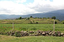
Zincirli is a village in the county İslahiye the Turkish province of Gaziantep . Zincirli is located in the north of the district near the road from İslahiye to Nurdağı, about ten kilometers north of the district town.
The village is located on the hill called Zincirli Höyük, a tell from which the remains of the citadel of the late Hittite-Aramaic city-state Sam'al were excavated.
Individual evidence
- ^ Turkish Institute for Statistics ( Memento from December 23, 2012 in the web archive archive.today ), accessed June 30, 2012


