
Zinna (Schöngleina)
|
Zinna
Community of Schöngleina
Coordinates: 50 ° 55 ′ 21 ″ N , 11 ° 43 ′ 48 ″ E
|
||
|---|---|---|
| Height : | 280 m above sea level NN | |
| Postal code : | 07646 | |
| Area code : | 036428 | |
Location of Zinna in Thuringia |
||
 Fruit in Zinna
|
||

Zinna is a part of the municipality of Schöngleina in the Saale-Holzland district in Thuringia .
geography
Zinna is on Landesstraße 2316, which has a connection to Bundesstraße 7 and is therefore well connected to the surrounding area. This road was an old trade route in the Middle Ages. The villages around Bürgel are a result of the development work carried out by the monks from the Bürgel monastery . They were mostly monastery-owned villages.
history
Zinna was first mentioned in a document on September 7, 1358. The manor and later chamber manor in Schöngleina and even the folk manor influenced the development of agriculture in Zinna. Only after the German reunification of the two German states did a recycling company develop in the hamlet , as well as the Heideland Gutsverwaltung , a large pig production company and a fruit farm.
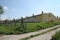
Pig production in Zinna

Web links
Individual evidence
- ↑ Rudolf Wolfram, Hans-Jochen Drafehn: The monastery church in Thalbürgel. Evangelische Verlagsanstalt, Berlin 1980, pp. 8, 9 and more often.
- ^ Wolfgang Kahl : First mention of Thuringian towns and villages. A manual. 5th, improved and considerably enlarged edition. Rockstuhl, Bad Langensalza 2010, ISBN 978-3-86777-202-0 , p. 325.