Zopatnitzenbach
| Zopatnitzenbach | ||
|
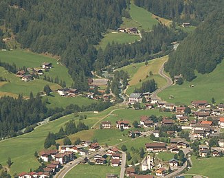
The Zopanitzenbach flows in the lower reaches through the district of Gritzach (left center) |
||
| Data | ||
| Water code | AT : 2-374-64-22 | |
| location | East Tyrol | |
| River system | Danube | |
| Drain over | Isel → Drau → Danube → Black Sea | |
| source | at the Berger See ( Villgratner Berge ) 46 ° 59 ′ 20 ″ N , 12 ° 21 ′ 43 ″ E |
|
| Source height | approx. 2178 m above sea level A. | |
| muzzle | near Gritzach in the Isel coordinates: 47 ° 0 '55 " N , 12 ° 22' 7" E 47 ° 0 '55 " N , 12 ° 22' 7" E |
|
| Mouth height | 1283 m above sea level A. | |
| Height difference | approx. 895 m
|
|
| Catchment area | 6.8 km² | |
| Flowing lakes | Arnitzsee | |
| Communities | Matrei in Osttirol , Virgen | |
The Zopatnitzenbach , also Zopanitzenbach , is a brook in the municipality of Prägraten am Großvenediger ( Lienz district ). The Zopatnitzenbach rises as an outflow of the Berger See and flows into the Isel near Gritzach .
course
The Zopatnitzenbach rises as an outflow of the Berger See directly next to the Berger-See-Hütte . It then flows through meadows and the Zopatnitzen corridor and then flows through wooded terrain in the middle and lower reaches. In the lower reaches of the Zopatnitzenbach falls over a waterfall and then enters the Virgental . The Zopatnitzenbach then flows through the few houses in Gritzach and then flows into the Isel on the right. A hiking trail runs east of the brook and leads from Prägraten to the Berger-See-Hütte and further south.
Individual evidence
- ↑ Tyrolean spatial information system
- ↑ Federal Ministry of Agriculture, Forestry, Environment and Water Management (Ed.): Area directory of the Austrian river basins: Draugebiet. Contributions to the hydrography of Austria, issue No. 59, Vienna 2011, p. 6 ( PDF; 3.5 MB )
