Aïn Harrouda: Difference between revisions
Content deleted Content added
m r2.6.4) (Robot: Modifying fr:Aïn Harrouda |
per WP:NOR and MOS:FORLANG |
||
| (23 intermediate revisions by 20 users not shown) | |||
| Line 3: | Line 3: | ||
<!-- Basic info ----------------> |
<!-- Basic info ----------------> |
||
|name =Aïn Harrouda |
|name =Aïn Harrouda |
||
| |
|native_name ={{native name|ar|ﻋﻴﻦ ﺣﺮﻭﺩﺓ}} |
||
|native_name = <!-- for cities whose native name is not in English --> |
|||
|nickname = |
|nickname = |
||
|settlement_type = |
|settlement_type = |
||
| Line 21: | Line 20: | ||
|mapsize = |
|mapsize = |
||
|map_caption = |
|map_caption = |
||
|pushpin_map |
| pushpin_map = Morocco#Africa |
||
| pushpin_relief = 1 |
|||
<!-- Location ------------------> |
<!-- Location ------------------> |
||
|coordinates_display = inline,title |
|||
|coordinates_region = MA |
|||
|subdivision_type = Country |
|subdivision_type = Country |
||
|subdivision_name = {{flag|Morocco}} |
|subdivision_name = {{flag|Morocco}} |
||
|subdivision_type1 = [[Regions of Morocco|Region]] |
|subdivision_type1 = [[Regions of Morocco|Region]] |
||
|subdivision_name1 = [[ |
|subdivision_name1 = [[Casablanca-Settat]] |
||
|subdivision_type2 =[[Provinces of Morocco| |
|subdivision_type2 = [[Provinces of Morocco|Prefecture]] |
||
|subdivision_name2 = |
|subdivision_name2 = [[Mohammedia]] |
||
|subdivision_type3 = |
|subdivision_type3 = |
||
|subdivision_name3 = |
|subdivision_name3 = |
||
| Line 44: | Line 42: | ||
<!-- Area ---------------------> |
<!-- Area ---------------------> |
||
|area_magnitude = |
|area_magnitude = |
||
|unit_pref =Imperial <!--Enter: Imperial, if Imperial (metric) is desired--> |
|||
|area_footnotes = |
|area_footnotes = |
||
|area_total_km2 = <!-- ALL fields dealing with a measurements are subject to automatic unit conversion--> |
|area_total_km2 = <!-- ALL fields dealing with a measurements are subject to automatic unit conversion--> |
||
|area_land_km2 = <!--See table @ Template:Infobox Settlement for details on automatic unit conversion--> |
|area_land_km2 = <!--See table @ Template:Infobox Settlement for details on automatic unit conversion--> |
||
<!-- Population -----------------------> |
<!-- Population -----------------------> |
||
|population_as_of = |
|population_as_of =2014 |
||
|population_footnotes =<ref name=census2014>{{cite web |url=http://rgph2014.hcp.ma/file/166326/ |title=POPULATION LÉGALE DES RÉGIONS, PROVINCES, PRÉFECTURES, MUNICIPALITÉS, ARRONDISSEMENTS ET COMMUNES DU ROYAUME D'APRÈS LES RÉSULTATS DU RGPH 2014 |language=ar, fr |publisher=[[Haut Commissariat au Plan|High Commission for Planning, Morocco]] |date=8 April 2015 |accessdate=29 September 2017}}</ref> |
|||
|population_footnotes = |
|||
|population_note = |
|population_note = |
||
|population_total = |
|population_total =62,420 |
||
|population_density_km2 = |
|population_density_km2 = |
||
|population_density_sq_mi = |
|population_density_sq_mi = |
||
| Line 58: | Line 55: | ||
|population_density_metro_km2 = |
|population_density_metro_km2 = |
||
|population_density_metro_sq_mi = |
|population_density_metro_sq_mi = |
||
|population_blank1_title =Ethnicities |
|||
|population_blank1 = |
|||
|population_density_blank1_km2 = |
|population_density_blank1_km2 = |
||
|population_density_blank1_sq_mi = |
|population_density_blank1_sq_mi = |
||
<!-- General information ---------------> |
<!-- General information ---------------> |
||
|timezone = [[ |
|timezone = [[Central European Time|CET]] |
||
|utc_offset = + |
|utc_offset = +1 |
||
|coordinates = {{coord|33|38|14|N|7|26|54|W|region:MA|display=inline,title}} |
|||
|timezone_DST = [[Western European Summer Time|WEST]] |
|||
|utc_offset_DST = +1 |
|||
|latd=33|latm=38|lats=14|latNS=N |
|||
|longd=7|longm=26|longs=54|longEW=W |
|||
|elevation_footnotes = <!--for references: use <ref> </ref> tags--> |
|elevation_footnotes = <!--for references: use <ref> </ref> tags--> |
||
|elevation_m = |
|elevation_m = 32 |
||
|elevation_ft = |
|elevation_ft = |
||
<!-- Area/postal codes & others --------> |
<!-- Area/postal codes & others --------> |
||
| Line 83: | Line 75: | ||
|footnotes = |
|footnotes = |
||
}} |
}} |
||
'''Aïn Harrouda''' ({{lang-ar|ﻋﻴﻦ ﺣﺮﻭﺩﺓ|ʿayn ḥarrūda}}) is a city in [[Morocco]], situated 17 km northeast of [[Casablanca]]. |
|||
It recorded a population of 62,420 in the [[2014 Moroccan census]].<ref name=census2014/> According to the 2004 census it had a population of 41,853 inhabitants.<ref>{{Cite web |url=http://www.hcp.ma/Recensement-general-de-la-population-et-de-l-habitat-2004_a633.html |title=2004 Morocco Population census |access-date=2011-07-14 |archive-date=2018-06-19 |archive-url=https://web.archive.org/web/20180619163929/https://www.hcp.ma/Recensement-general-de-la-population-et-de-l-habitat-2004_a633.html |url-status=dead }}</ref> |
|||
==See also== |
|||
[[Grand Casablanca]]<br /> |
|||
| ⚫ | |||
[[Mohammedia]] |
|||
==References== |
==References== |
||
{{reflist}} |
|||
<references/> |
|||
{{Template:Grand Casablanca}} |
|||
| ⚫ | |||
{{DEFAULTSORT:Ain Harrouda}} |
{{DEFAULTSORT:Ain Harrouda}} |
||
[[Category: |
[[Category:Populated places in Casablanca-Settat]] |
||
[[Category:Populated places in the Greater Casablanca Region]] |
|||
{{CasablancaSettat-geo-stub}} |
|||
[[fr:Aïn Harrouda]] |
|||
[[it:Ain Harrouda]] |
|||
[[sv:Aïn Harrouda]] |
|||
Latest revision as of 12:07, 14 March 2024
Aïn Harrouda
ﻋﻴﻦ ﺣﺮﻭﺩﺓ (Arabic) | |
|---|---|
| Coordinates: 33°38′14″N 7°26′54″W / 33.63722°N 7.44833°W | |
| Country | |
| Region | Casablanca-Settat |
| Prefecture | Mohammedia |
| Elevation | 32 m (105 ft) |
| Population (2014)[1] | |
| • Total | 62,420 |
| Time zone | UTC+1 (CET) |
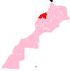
Aïn Harrouda (Arabic: ﻋﻴﻦ ﺣﺮﻭﺩﺓ, romanized: ʿayn ḥarrūda) is a city in Morocco, situated 17 km northeast of Casablanca.
It recorded a population of 62,420 in the 2014 Moroccan census.[1] According to the 2004 census it had a population of 41,853 inhabitants.[2]
References[edit]
- ^ a b "POPULATION LÉGALE DES RÉGIONS, PROVINCES, PRÉFECTURES, MUNICIPALITÉS, ARRONDISSEMENTS ET COMMUNES DU ROYAUME D'APRÈS LES RÉSULTATS DU RGPH 2014" (in Arabic and French). High Commission for Planning, Morocco. 8 April 2015. Retrieved 29 September 2017.
- ^ "2004 Morocco Population census". Archived from the original on 2018-06-19. Retrieved 2011-07-14.


