Settat
| Settat | ||||
|---|---|---|---|---|
|
||||
| Basic data | ||||
| State : |
|
|||
| Region : | Casablanca Settat | |||
| Province : | Settat | |||
| Coordinates | 33 ° 1 ′ N , 7 ° 38 ′ W | |||
| Residents : | 142,250 (2014) | |||
| Area : | 54.7 km² | |||
| Population density : | 2,601 inhabitants per km² | |||
| Height : | 380 m | |||
| City administration website : | ||||
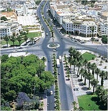
| Settat - city center | ||||
Settat ( Arabic سطات, Central Atlas Tamazight ⵙⵟⵟⴰⵟ Settat ) is a city of about 150,000 inhabitants in the region Grand Casablanca-Settat in the west of Morocco ; it is the capital of the province of the same name .
location
The city of Settat is located in the center of the fertile and historically significant region of the Chaouia at an altitude of approx. 370 to 390 m, approx. 84 km (driving distance) south of Casablanca and approx. 170 km north of Marrakech . The city is connected to the Moroccan motorway network via the A7. The climate is largely influenced by the Atlantic , but the average annual rainfall (approx. 370 mm) is already significantly lower than in Rabat or Casablanca.
population
| year | 1994 | 2004 | 2014 |
| Residents | 96,883 | 117,375 | 142,250 |
Most of the inhabitants who immigrated from the surrounding villages and mountain regions of the Middle and High Atlas in the second half of the 20th century are mostly of Berber descent. However, the colloquial language is usually Moroccan Arabic .
economy
In the villages around Settat, agriculture is practiced on a large scale; Animal husbandry (sheep, goats, chickens), on the other hand, has become rather rare. The city itself functions as a regional craft, trade and service center and offers the service, training and health centers that are important for the region.
history
The Chaouia region was the tribal area of numerous nomadic Berber tribes - in the Middle Ages and afterwards there were numerous conflicts but also coalitions with the Moroccan sultan power . Mulai Ismail (ruled 1672–1727) had a kasbah built for better control of the Berbers . Until the first decades of the 20th century, however, Settat remained only a larger Berber village with around 3,000 inhabitants and a few administrative officials. During the protectorate period (1912–1956) and especially after the independence of Morocco, the town, which was made provincial capital in 1967, grew to its present size.
Attractions
- The predominantly modern city has a partially preserved fortress (Kasbah Ismaïlia) from the late 17th century (see also Boulaouane ). The walls, which were partially destroyed during the protectorate, were restored after independence.
- In the immediate vicinity is the Sidi El Ghamli Mosque , the new minaret of which is reminiscent of that of the Hassan II Mosque in Casablanca.
Personalities
- Driss Basri (1938–2007), Moroccan politician, was born in Settat.
- Mohamed Moâtassim (* 1956), professor, author and advisor to Mohammed VI.
Twin cities
-
 La Celle-Saint-Cloud , France
 -
 Tours , France
 -
 Burgos , Spain
 -
 Wurzburg , Germany


