
Main Line (Long Island Rail Road): Difference between revisions
→Full list, including all former stations: reference proving Holbrook Station's existance |
→Full list, including all former stations: Holtsville station pic referred, Holbrook Station reference fixed |
||
| Line 367: | Line 367: | ||
|[[Holbrook (LIRR station)|Holbrook]] |
|[[Holbrook (LIRR station)|Holbrook]] |
||
|1844 |
|1844 |
||
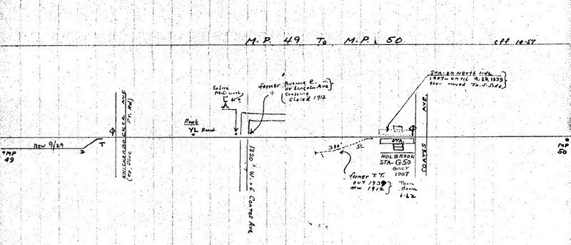
|1962<ref>[http://trainsarefun.com/lirr/lirrtrackmaps/MP49-50%20ronk.jpg Holbrook Station @ Ronkonkoma MP 49-50; |
|1962<ref>[http://trainsarefun.com/lirr/lirrtrackmaps/MP49-50%20ronk.jpg Holbrook Station @ Ronkonkoma MP 49-50; October 1957(TrainsAreFun.com)]</ref> |
||
|- bgcolor=dfdfdf |
|- bgcolor=dfdfdf |
||
| |
| |
||
|[[Holtsville (LIRR station)|Holtsville]]<br>earlier [[Waverly (LIRR station)|Waverly]] |
|[[Holtsville (LIRR station)|Holtsville]]<br>earlier [[Waverly (LIRR station)|Waverly]]<ref>[http://www.lirrhistory.com/mar2002/holts12.jpg May 13, 1912 Photo @ Ron Zeil collection (Unofficial LIRR History Website)]</ref> |
||
|1843 |
|1843 |
||
|1998 |
|1998 |
||
Revision as of 18:48, 6 November 2007
The Main Line is a rail line owned and operated by the Long Island Rail Road in the U.S. state of New York. It begins in Long Island City and runs directly across the middle of Long Island, terminating in Greenport approximately 95 miles (153 km) from its starting point. Along the way, the Main Line spawns five branches. These branches, in order from west to east, are:
- Port Washington Branch (at Harold Interlocking in Sunnyside, Queens)
- Hempstead Branch (at Queens Interlocking along the Queens/Nassau County border)
- Oyster Bay Branch (at Nassau Interlocking in Mineola)
- Port Jefferson Branch (at Divide Interlocking in Hicksville)
- Central Branch (at Beth Interlocking at Bethpage)
Third Main Line track
In order to accommodate an expected increase in Long Island Rail Road ridership once the East Side Access project to Grand Central Terminal is completed and to expand local and reverse peak service, the Metropolitan Transportation Authority has proposed to build a third Main Line track from Bellerose to Mineola in its 2005-2009 capital program.[1][2] The track would eventually be extended to Hicksville. Components of the project include purchasing properties in the track's right of way, eliminating grade crossings (in conjunction with NYSDOT), relocating existing stations, and reconfiguring Mineola Station. Fierce opposition for building a third track comes from the villages of Floral Park, New Hyde Park, and Garden City,[3][4][5] which say the construction and the resulting increased train service will reduce the quality of life in their neighborhoods. However, these villages do support station improvements and the elimination of grade crossings.
History
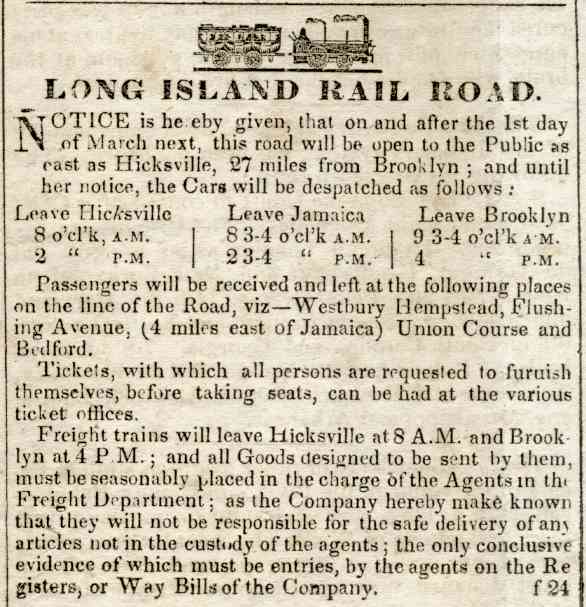
The Main Line opened beyond Jamaica to Hicksville on March 1, 1837; shortly afterwards, the Panic of 1837 severely curtailed construction. It was extended to Farmingdale on October 15, 1841, Deer Park on March 14, 1842, Brentwood on June 24, Central Islip on July 14, and Yaphank on June 26, 1844. An opening excursion to Greenport was operated on July 27, 1844, and revenue service began over the full line on July 29.[6][7][8][9]
Stations
Hempstead Branch trains split off after Queens Village, Oyster Bay Branch trains split off after Mineola, and Port Jefferson Branch trains split off after Hicksville. Montauk Branch trains that use the Main Line and Central Branch split off after Bethpage, but only stop at Mineola and Hicksville east of Jamaica.
Jamaica is 10.8 miles (17.4 km) from Penn Station.
| Station/ location |
Miles (kilometers) from Jamaica[10] |
Notes |
|---|---|---|
| Long Island City |
||
| Hunterspoint Avenue | ||
| Woodside |
5.9 (9.5) | Transfer to Port Washington Branch |
| Forest Hills |
2.3 (3.7) | |
| Kew Gardens | 2.0 (3.2) | |
| Jamaica |
0.0 (0.0) | |
| Hillside Facility | Employee-only station | |
| Hollis 193rd Street and Woodhull Avenue, Hollis |
2.6 (4.2) | |
| Queens Village Springfield Boulevard and Amboy Lane, Queens Village |
4.2 (6.8) | |
| Floral Park Tulip Avenue and Atlantic Avenue, Floral Park |
5.9 (9.5) | Transfer to Hempstead Branch |
| New Hyde Park New Hyde Park and 2nd Avenue, New Hyde Park |
7.2 (11.6) | |
| Merillon Avenue Nassau Boulevard and Merillon Avenue, New Hyde Park |
8.3 (13.4) | |
| Mineola Front Street and Mineola Boulevard, Mineola |
9.5 (15.3) | Transfer to Oyster Bay Branch |
| Carle Place Cherry Lane and Atlantic Avenue, Carle Place |
11.3 (18.2) | |
| Westbury Union Avenue and Post Avenue Westbury |
12.4 (20.0) | |
| Hicksville Newbridge Road (Route 106) and West Barclay Street, Hicksville |
15.8 (25.4) | Transfer to Port Jefferson Branch |
| Bethpage Stewart Avenue and Jackson Avenue, Bethpage |
18.9 (30.4) | |
| Farmingdale Off Secatogue Avenue, on Front Street and Atlantic Avenue, Farmingdale |
21.2 (34.1) | |
| Pinelawn Wellwood Avenue and Long Island Avenue, Pinelawn Memorial Park |
23.4 (37.7) | |
| Wyandanch Straight Path and Long Island Avenue, Wyandanch |
25.7 (41.4) | |
| Deer Park Pine Aire Drive and Long Island Avenue, Deer Park |
29.4 (47.3) | |
| Brentwood Brentwood Road and Suffolk Avenue, Brentwood |
32.1 (51.7) | |
| Central Islip Lowell Avenue and Suffolk Avenue,Central Islip |
36.4 (58.6) | |
| Ronkonkoma Hawkins Avenue and Johnson Avenue, Ronkonkoma |
39.5 (63.6) | |
| Medford Medford Avenue (New York State Route 112) and Long Island Avenue, Medford |
45.1 (72.6) | |
| Yaphank Yaphank Avenue and Park Street, Yaphank |
49.6 (79.8) | |
| Riverhead Osborne Avenue and Railroad Street, Riverhead |
64.1 (103.2) | |
| Mattituck Love Lane and Pike Street, Mattituck |
73.4 (118.1) | |
| Southold Youngs Avenue and Traveler Street, Southold |
81.1 (130.5) | |
| Greenport Wiggins Street and 4th Street, Greenport |
85.3 (137.3) | Ferry to Shelter Island and New London, Connecticut |
Full list, including all former stations
References
- ^ Main Line Corridor Improvements EIS
- ^ Main Line Corridor Improvements Project brochure
- ^ Stephanie Mariel Petrellese (2005-11-11). "Floral Park Mayor To Address LIRR Expansion". The Garden City News. Retrieved 2006-12-23.
- ^ Carisa Keane (2005-06-24). "Residents: MTA/LIRR Needs to Get on Right Track". New Hyde Park Illustrated News. Retrieved 2006-12-23.
- ^ Stephanie Mariel Petrellese (2006-12-15). "Village Meets With LIRR On "Third Track" Project". The Garden City News. Retrieved 2006-12-23.
- ^ Template:PDFlink, June 2004 Edition
- ^ Template:PDFlink, May 2004 Edition
- ^ Template:PDFlink, May 2004 Edition
- ^ Template:PDFlink, May 2004 Edition
- ^ Station pages linked from LIRR Map
- ^ a b c d e f g h Employee timetable, November 5, 1905
- ^ a b Template:Cite BDE
- ^ a b c d Brooklyn Advocate, Long Island Rail Road, February 1837
- ^ Template:Cite BDE
- ^ Template:Cite BDE
- ^ Template:Cite BDE
- ^ Template:Cite BDE
- ^ Template:Cite BDE
- ^ Holbrook Station @ Ronkonkoma MP 49-50; October 1957(TrainsAreFun.com)
- ^ May 13, 1912 Photo @ Ron Zeil collection (Unofficial LIRR History Website)
- ^ a b c Template:Cite BDE
| Main routes |   | ||||
|---|---|---|---|---|---|
| Branch services | |||||
| Freight operations |
| ||||
| Defunct branches | |||||
| Acquired railroads | |||||
| Other | |||||