Abinger
| Abinger | |
|---|---|
 Abinger Common fields | |
| Population | 1,958 [1] |
| OS grid reference | TQ 112014 |
| District | |
| Shire county | |
| Region | |
| Country | England |
| Sovereign state | United Kingdom |
| Post town | Dorking |
| Postcode district | RH5 |
| Police | Surrey |
| Fire | Surrey |
| Ambulance | South East Coast |
| UK Parliament | |
Abinger is a large civil parish in the Mole Valley district of Surrey England between Dorking, Gomshall and Ewhurst. It includes Abinger Hammer, Sutton Abinger, Abinger Common, Forest Green, Walliswood, Oakwood Hill, and outskirts of Holmbury St Mary (most of which is in Shere).[2]
Geography
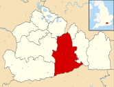
The upper reach of the Tilling Bourne runs through Abinger Hammer from east to west and is joined by the Holmbury St Mary stream on the western border. In the southwest by Sutton Abinger are Pasture Wood and Oxmoor Copse, lower slopes of the Greensand Ridge. Southeast the land approaches the highest point in the Greensand Ridge, climbing through Abinger Common, more than half way up Leith Hill, reaching in the south-east corner of the parish an elevation of 248 m above sea level[3]. Similarly to the north the parish reaches the top of the North Downs, in the protrusion part of Mole Valley shown in the map above, across Abinger Roughs including the highest point before the northern boundary, in Oaken Grove, 227 m above sea level. The lowest point is where the Tilling Bourne flows into Gomshall at 85 m. The entire area is in the Surrey Hills AONB.
Transport
Only Abinger Hammer lies on the A25 Guildford to Dorking road with the remainder of the area served by more minor roads. The nearest railway station is nearby to the west at Gomshall on the Reading to Gatwick line.
History

The area has been inhabited for a long time with a mesolithic burial site on the south east of Sutton Abinger. There is also evidence of strip farming.[4]
Abinger appears in the Domesday Book as Abinceborne. It was held by William de Braiose. Its Domesday Assets were 4 hides. 1 church, 1 mill worth 6s, 7 ploughs, 3 acres (12,000 m2) of meadow, woodland worth 40 hogs. It rendered (in total): £7.[5]
The church of the Abingers is the C of E church of St James at Abinger Common, which is a II* class listed building.[6]
The church of St John the Baptist in Walliswood also has class II* listed building status.[7]


Sutton Abinger has a pub called The Volunteer and {convert|1⁄2|mile|km} east in Abinger Common is the Scheduled Ancient Monument Motte "Castle" at Abinger Manor[8], the grade II listed manor itself [9] and opposite St James Church, see above, are stocks [10] and a public house The Abinger Hatch with a green picnic area [11]
Fulvens House which also lies between the Abingers actually over the western border [12][13] and it may date back to 1628[14].
Demographics, Population and Economy
It has a population of 1,858 and covers an area of 30.17 square kilometres (11.65 sq mi).[15]
Sport and Amenities

Cricket is played across the parish, with a notable team at Abinger Hammer.
Notable Inhabitants
- Baron Abinger
- Prunella Scales was born in Sutton Abinger in 1932.
References
- ^ Census
- ^ [www.abinger-pc.gov.uk "Home page"]. Abinger Parish Council. Retrieved 5 May 2012.
{{cite web}}: Check|url=value (help) - ^ "Elevation tool finder". Retrieved 5 May 2012.
- ^ Surrey Archaeology
- ^ Surrey Domesday Book
- ^ Historic England. "Details from listed building database (1378082)". National Heritage List for England.
- ^ Historic England. "Details from listed building database (1028844)". National Heritage List for England.
- ^ Historic England. "Details from listed building database (1012579)". National Heritage List for England.
- ^ Historic England. "Details from listed building database (1028827)". National Heritage List for England.
- ^ Historic England. "Details from listed building database (1028840)". National Heritage List for England.
- ^ Historic England. "Details from listed building database (1378083)". National Heritage List for England.
- ^ Fulvens House photo
- ^ Properties from Times On Line
- ^ Historic England. "Details from listed building database (1294281)". National Heritage List for England.
- ^ 2001 census

