
Alt-Berlin: Difference between revisions
typo |
mNo edit summary |
||
| (23 intermediate revisions by 20 users not shown) | |||
| Line 1: | Line 1: | ||
{{ |
{{redirect|Old Berlin||History of Berlin}} |
||
{| cellpadding="2" style="float: right; width: 307px; background: #40E0D0; margin-left: 1em; border-spacing: 1px;" |
{| cellpadding="2" style="float: right; width: 307px; background: #40E0D0; margin-left: 1em; border-spacing: 1px;" |
||
! Coat of Arms |
! Coat of Arms |
||
| Line 7: | Line 7: | ||
<small>Seal of 1280</small> |
<small>Seal of 1280</small> |
||
| [[File:Karte berlin stadthaus3.png|165px]]<br> |
| [[File:Karte berlin stadthaus3.png|165px]]<br> |
||
<small>Alt-Berlin within city |
<small>Alt-Berlin within Berlin's [[Mitte (locality)|city center]] </small> |
||
|- |
|- |
||
! colspan=2 | Basic Information |
! colspan=2 | Basic Information |
||
| Line 16: | Line 16: | ||
|- style="background: #ffffff;" |
|- style="background: #ffffff;" |
||
| [[Boroughs and localities of Berlin|Locality]]: || [[Mitte (locality)|Mitte]] |
| [[Boroughs and localities of Berlin|Locality]]: || [[Mitte (locality)|Mitte]] |
||
|- style="background: #ffffff;" |
|||
| [[Area]]: || ? |
|||
|- style="background: #ffffff;" |
|||
| [[Population]]: || ? |
|||
|- style="background: #ffffff;" |
|- style="background: #ffffff;" |
||
| [[Coordinate system|Coordinates]]: || {{Coord|52|31|05|N|13|24|34|E|region:DE-BE_type:city|display=inline,title}} |
| [[Coordinate system|Coordinates]]: || {{Coord|52|31|05|N|13|24|34|E|region:DE-BE_type:city|display=inline,title}} |
||
| Line 25: | Line 21: | ||
| [[Elevation]]: || 34 m (111 ft) above [[sea level]] |
| [[Elevation]]: || 34 m (111 ft) above [[sea level]] |
||
|} |
|} |
||
[[File:Stadtviertel in Berlin-Mitte.png|thumb|300px|Neighborhoods in [[Berlin-Mitte]]: [[Cölln|Old Cölln]] [1] (with [[Museum Island]] [1a], [[ |
[[File:Stadtviertel in Berlin-Mitte.png|thumb|300px|Neighborhoods in [[Berlin-Mitte]]: [[Cölln|Old Cölln]] [1] (with [[Museum Island]] [1a], [[Fischerinsel|Fisher Island]] [1b]), Alt-Berlin [2] (with [[Nikolaiviertel]] [2a]), [[Friedrichswerder]] [3], [[Neukölln am Wasser]] [4], [[Dorotheenstadt]] [5], [[Friedrichstadt (Berlin)|Friedrichstadt]] [6], [[Luisenstadt]] [7], [[Stralauer Vorstadt]] (with [[Königsstadt]]) [8], [[Alexanderplatz]] Area (Königsstadt and Altberlin) [9], [[Spandauer Vorstadt]] [10] (with [[Scheunenviertel]] [10a]), [[Friedrich-Wilhelm-Stadt]] [11], [[Oranienburger Vorstadt]] [12], [[Rosenthaler Vorstadt]] [13] ]] |
||
'''Alt-Berlin''' ( |
'''Alt-Berlin''' ("Old Berlin"), also spelled ''Altberlin'', is a [[Boroughs and neighborhoods of Berlin|neighborhood]] (''Stadtviertel''), situated in the [[Berlin]]er [[Boroughs and localities of Berlin|locality]] (''Ortsteil'') of [[Mitte (locality)|Mitte]], part of the [[Mitte|homonymous borough]]. In the 13th century it was the sister town of the old [[Cölln]], located on the northern [[Spree (river)|Spree]] Island in the [[Margraviate of Brandenburg]]. The neighbourhoods (''Viertel'') of [[Nikolaiviertel]], Marienviertel, Klosterviertel are within Alt-Berlin. |
||
<ref>{{cite web |
|||
|url=https://www.stattreisenberlin.de/ueber-berlin/lieblingsorte/das-klosterviertel/ |
|||
|title=Das Klosterviertel - Zu unrecht wenig beachtet |
|||
|author=Ralph Hoppe |
|||
|website=StattReisen Berlin |
|||
|publisher=StattReisen Berlin |
|||
|access-date=2023-04-25 |
|||
}}</ref> |
|||
==History== |
==History== |
||
[[File:ZLB-Berliner Ansichten-Januar.jpg|thumb|left|185px|Central Berlin map of 1688 with Altberlin shown in |
[[File:ZLB-Berliner Ansichten-Januar.jpg|thumb|left|185px|Central Berlin map of 1688 with Altberlin shown in pink]] |
||
{{see also|History of Berlin|Cölln#History|l2=History of Cölln}} |
{{see also|History of Berlin|Cölln#History|l2=History of Cölln}} |
||
First mentioned in 1244, 7 years after Cölln, it represents the original core of the modern Berlin. The first stone fortification was built, to defend both cities, in 1250 and in 1251 it gained |
First mentioned in 1244, 7 years after Cölln, it represents the original core of the modern Berlin. The first stone fortification was built, to defend both cities, in 1250 and in 1251 it gained [[German town law|city rights]]. In 1280 Berlin, gained the right to mint currency. In that period it appeared on a [[coat of arms]] for the first time, close to the symbol of the [[Reichsadler|imperial eagle]], two stylized [[bear]]s, antecedents of the bear currently serving as the [[Coat of arms of Berlin|symbol of the city]]. On 20 March 1307 the town was united with Cölln (maintaining its name, Berlin) forming a trading union on political and security matters, and participated in the [[Hanseatic League]].<ref>{{in lang|de}} [http://www.berlin.de/berlin-im-ueberblick/geschichte/handelsstadt.en.html Medieval history of Berlin]</ref><ref>{{in lang|de}} [http://www.brandenburg1260.de/berlin.html Historical infos about Cölln and Alt-Berlin on www.brandenburg1260.de]</ref> |
||
==Geography== |
==Geography== |
||
| Line 38: | Line 42: | ||
==Photogallery== |
==Photogallery== |
||
<gallery widths=112> |
<gallery widths="112"> |
||
File:Berlin |
File:Neptun-Brunnen-Rotes-Rathaus-Alexanderplatz-Berlin.jpg|alt=Rotes Rathaus, the city hall of Berlin with Neptunbrunnnen in front|''[[Rotes Rathaus]]'', the city hall of Berlin and [[Neptunbrunnen (Berlin)|Neptunbrunnen]] |
||
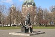
File:Marx & Engels.jpg|The ''[[Marx-Engels-Forum]]'' |
File:Marx & Engels.jpg|The ''[[Marx-Engels-Forum]]'' |
||
File: |
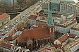
File:View Berlin TV Tower Jan2015 img4.jpg|Aerial view of the [[St. Nicholas Church, Berlin|Nikolaikirche]] in the [[Nikolaiviertel]] |
||
File:Franziskaner-Klosterkirche Berlin Mitte.jpg|Ruins of the so-called "Gray Monastery" |
|||
</gallery> |
</gallery> |
||
| Line 55: | Line 60: | ||
[[Category:History of Berlin]] |
[[Category:History of Berlin]] |
||
[[Category:Mitte]] |
[[Category:Mitte]] |
||
[[de:Alt-Berlin]] |
|||
[[fr:Altberlin]] |
|||
[[nl:Alt-Berlin]] |
|||
Latest revision as of 19:11, 11 March 2024
| Coat of Arms | Map |
|---|---|
 Seal of 1280 |
 Alt-Berlin within Berlin's city center |
| Basic Information | |
| City: | Berlin |
| Borough: | Mitte |
| Locality: | Mitte |
| Coordinates: | 52°31′05″N 13°24′34″E / 52.51806°N 13.40944°E |
| Elevation: | 34 m (111 ft) above sea level |

Alt-Berlin ("Old Berlin"), also spelled Altberlin, is a neighborhood (Stadtviertel), situated in the Berliner locality (Ortsteil) of Mitte, part of the homonymous borough. In the 13th century it was the sister town of the old Cölln, located on the northern Spree Island in the Margraviate of Brandenburg. The neighbourhoods (Viertel) of Nikolaiviertel, Marienviertel, Klosterviertel are within Alt-Berlin. [1]
History[edit]

First mentioned in 1244, 7 years after Cölln, it represents the original core of the modern Berlin. The first stone fortification was built, to defend both cities, in 1250 and in 1251 it gained city rights. In 1280 Berlin, gained the right to mint currency. In that period it appeared on a coat of arms for the first time, close to the symbol of the imperial eagle, two stylized bears, antecedents of the bear currently serving as the symbol of the city. On 20 March 1307 the town was united with Cölln (maintaining its name, Berlin) forming a trading union on political and security matters, and participated in the Hanseatic League.[2][3]
Geography[edit]
Alt-Berlin, crossed at its southern borders by the river Spree, is located in the middle of the city. Its northern borders are represented, except for the square area of Alexanderplatz, by the Stadtbahn railway line between the station of Jannowitzbrücke and a rail bridge after Hackescher Markt station.
Photogallery[edit]
-
 Rotes Rathaus, the city hall of Berlin and Neptunbrunnen
 -
-
 Aerial view of the Nikolaikirche in the Nikolaiviertel
 -
 Ruins of the so-called "Gray Monastery"


References[edit]
- ^ Ralph Hoppe. "Das Klosterviertel - Zu unrecht wenig beachtet". StattReisen Berlin. StattReisen Berlin. Retrieved 2023-04-25.
- ^ (in German) Medieval history of Berlin
- ^ (in German) Historical infos about Cölln and Alt-Berlin on www.brandenburg1260.de
External links[edit]
![]() Media related to Alt-Berlin at Wikimedia Commons
Media related to Alt-Berlin at Wikimedia Commons
| |||