
Cap Tourmente National Wildlife Area: Difference between revisions
m standard quote handling in WP;standard Apostrophe/quotation marks in WP; MOS general fixes |
Added wikilinks |
||
| (25 intermediate revisions by 20 users not shown) | |||
| Line 1: | Line 1: | ||
{{Short description|National Wildlife Area in Quebec, Canada}} |
|||
{{Expand French|Réserve nationale de faune du cap Tourmente|topic=geo|date=April 2010}} |
|||
{{Use mdy dates|date=November 2022}} |
|||
{{Infobox protected area |
{{Infobox protected area |
||
| name = Cap Tourmente National Wildlife Area |
| name = Cap Tourmente National Wildlife Area |
||
| Line 29: | Line 30: | ||
}} |
}} |
||
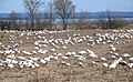
The '''Cap Tourmente National Wildlife Area''' is a [[National Wildlife Area]] located on the north shore of the [[Saint Lawrence River]] in the [[Capitale-Nationale|National Capital Region]] of [[Quebec]] established on 28 April 1978. It is critical |
The '''Cap Tourmente National Wildlife Area''' is a [[National Wildlife Area]] (NWA) located on the north shore of the [[Saint Lawrence River]] in the [[Capitale-Nationale|National Provincial Capital Region]] of [[Quebec]], established on 28 April 1978. It is one of the critical habitats for the [[greater snow goose]] during migration. Flocks of tens of thousands of these birds stop over to feed on the [[bullrush]]es in the spring and fall. The [[tidal marsh]] was recognized as a wetland of international significance per the [[Ramsar Convention]] in 1981, the first North American site to receive that distinction.<ref name="first">{{Cite web |
||
|url=http://www.hww.ca/hww2.asp?cid=7&id=44 |
|url=http://www.hww.ca/hww2.asp?cid=7&id=44 |
||
|title=Greater Snow Goose |
|title=Greater Snow Goose |
||
| Line 36: | Line 37: | ||
|accessdate=2010-12-15 |
|accessdate=2010-12-15 |
||
|quote=In 1981, the Cap Tourmente NWA was declared North America's first Ramsar site, a site recognized as a wetland of international importance. |
|quote=In 1981, the Cap Tourmente NWA was declared North America's first Ramsar site, a site recognized as a wetland of international importance. |
||
| |
|url-status=dead |
||
|archiveurl=https://web.archive.org/web/20101205074343/http://www.hww.ca/hww2.asp?cid=7&id=44 |
|archiveurl=https://web.archive.org/web/20101205074343/http://www.hww.ca/hww2.asp?cid=7&id=44 |
||
|archivedate=2010-12-05 |
|archivedate=2010-12-05 |
||
|df= |
|||
}}</ref> |
}}</ref> |
||
| ⚫ | Within the wildlife refuge is a historic farm site, La Petite-Ferme du cap Tourmente, which was begun by [[Samuel de Champlain]] in 1626, as a food source for the fledgling [[Habitation de Quebec|Habitation]] at [[Quebec City]]. Later, the farm was purchased and run for nearly 300 years by and for the [[Seminaire de Quebec|Seminary of Quebec]]. A farm house built around 1667 still stands, and is at the core of La Petite-Ferme du cap Tourmente [[National Historic Sites of Canada|National Historic Site]], designated in 2018.<ref> |
||
<gallery> |
<gallery> |
||
File:CapTourmenteOieBlanche.JPG|[[Snow goose]] |
File:CapTourmenteOieBlanche.JPG|[[Snow goose]] |
||
File:Spizelloides arborea CT5.jpg|[[American tree sparrow]] (Spizelloides arborea) |
File:Spizelloides arborea CT5.jpg|[[American tree sparrow]] (''Spizelloides arborea'') |
||
</gallery> |
</gallery> |
||
== Location == |
|||
Cap Tourmente is 50 km from [[Quebec City]], and sits on the [[St. Lawrence River]]. The park is part of [[Saint-Joachim, Quebec|Saint-Joachim]] municipality. The location of the park sits at an intersection of [[Appalachian Mountains]], [[Canadian Shield]], the [[St. Lawrence Lowlands]].<ref name=":32">{{Cite web |last=Canada |first=Environment and Climate Change |date=2017-12-08 |title=Cap Tourmente National Wildlife Area |url=https://www.canada.ca/en/environment-climate-change/services/national-wildlife-areas/locations/cap-tourmente.html |access-date=2022-10-14 |website=www.canada.ca}}</ref> Because of this, the park has a wide range of mountain views, marshlands, and plains, leading to diverse habitats and a diversity of [[plant]] and [[animal]] species. The [[Marsh|marshlands]] of the park serve as many birds' migratory stopovers and breeding areas, which contributes to its importance as a protected area. The area is located at 47°03.860' N 70°47.774' W.<ref name=":32" /> |
|||
== History == |
|||
A number of prehistoric [[Amerindian]] artifacts are found on the coastal plain, providing evidence of the presence of Indigenous peoples for over 2,000 years, starting at least 2,400 years ago. The evidence suggests the area was occupied by small bands of St. Lawrence [[Iroquoian peoples|Iroquoians]], who were the dominant group in the St. Lawrence Valley for several centuries before the arrival of [[European colonization of the Americas|Europeans]]. They subsisted on [[agriculture]], hunting and fishing in the St. Lawrence Valley region.<ref name=":4">{{Cite web |last=Canada |first=Environment and Climate Change |date=2022-01-11 |title=Cap Tourmente National Wildlife Area: management plan 2020 |url=https://www.canada.ca/en/environment-climate-change/services/national-wildlife-areas/locations/cap-tourmente/management-plan.html |access-date=2022-11-07 |website=www.canada.ca}}</ref> In the late 16th century, the St. Lawrence Iroquoians mysteriously disappeared, abandoning their former territories sometime between the last voyage of the French [[Exploration|explorer]] [[Jacques Cartier]] in 1541—Cap Tourmente was the first land fall for [[Jacques Cartier]] in 1535—and the subsequent expedition of [[Samuel de Champlain]] in 1603.<ref>{{Cite web |title=St Lawrence Iroquoians {{!}} The Canadian Encyclopedia |url=https://www.thecanadianencyclopedia.ca/en/article/st-lawrence-iroquoians |access-date=2022-11-07 |website=www.thecanadianencyclopedia.ca}}</ref> |
|||
| ⚫ | Within the wildlife refuge is a historic [[farm]] site, La Petite-Ferme du cap Tourmente, which was begun by [[Samuel de Champlain]] in 1626, as a food source for the fledgling [[Habitation de Quebec|Habitation]] at [[Quebec City]]. Later, the farm was purchased and run for nearly 300 years by and for the [[Seminaire de Quebec|Seminary of Quebec]]. A farm house built around 1667 still stands, and is at the core of La Petite-Ferme du cap Tourmente [[National Historic Sites of Canada|National Historic Site]], designated in 2018.<ref name=":2">{{Cite web |last=Canada |first=Parks |date=2018-03-27 |title=Government of Canada Announces 12 New National Historic Designations |url=https://www.canada.ca/en/parks-canada/news/2018/03/government-of-canada-announces-12-new-national-historic-designations.html |access-date=2022-10-14 |website=www.canada.ca}}</ref> |
||
The Canadian government acquired the area in 1969. It was later recognised as a [[National Wildlife Area]] in 1978 and as a [[wetland]] of significance per the [[Ramsar Convention]] in 1981. |
|||
== Wildlife == |
|||
The Cap Tourmente National Wildlife Area has a wide range of [[Habitat|habitats]] and comprises 400 hectares of [[tidal marsh]], 100 hectares of [[coastal meadow]], 700 hectares of [[agricultural land]] and 1198 hectares of [[forest]].<ref name=":0">{{Cite web |title=Cap Tourmente {{!}} Ramsar Sites Information Service |url=https://rsis.ramsar.org/ris/214 |access-date=2022-10-14 |website=rsis.ramsar.org}}</ref> It is the home to a wide range of animals and plants, including more than 200 animal species and 700 plant species. The intertidal bulrush, coastal bulrush and [[coastal plain]] and [[Temperate broadleaf and mixed forests|mixed-forest]] plateau provides crucial habitat for the staging of [[Bird migration|migratory birds]] and serves as birds' breeding grounds. The [[keystone species]] of the NWA include [[greater snow goose]], [[peregrine falcon]], and [[warbler]]s in spring.<ref name=":3">{{Cite web |last=Canada |first=Environment and Climate Change |date=2017-12-08 |title=Cap Tourmente National Wildlife Area |url=https://www.canada.ca/en/environment-climate-change/services/national-wildlife-areas/locations/cap-tourmente.html |access-date=2022-10-14 |website=www.canada.ca}}</ref> |
|||
=== Plants === |
|||
==== Intertidal marsh ==== |
|||
The Cap Tourmente NWA was created mainly to protect the vast amount of [[Intertidal wetland|intertidal marshes]] that are present in the NWA, especially the American bulrushes, which attracts tens of thousands of greater snow geese during the spring and fall migration period. These marshes occupy 2,500 hectares and include close to 60% of all the [[bulrush]] marshes in Québec.<ref>{{Cite web |title=BirdLife Data Zone |url=http://datazone.birdlife.org/site/factsheet/cap-tourmente-iba-canada |access-date=2022-11-07 |website=datazone.birdlife.org}}</ref> Heavy [[tidal flooding]] by fresh waters on the coastal flats covers a large amount of intertidal marsh. The intertidal marshes in the NWA can be divided into three separate zones, including the upper, middle, and the lower zone. All three zones are predominantly dominated by American bulrushes. [[Wild rice|Southern wild rice]] (''Zizania aquatica'') and [[Sagittaria latifolia|broad-leaved arrowhead]] (''Sagittaria latifolia'') are also present in the upper and the middle zone. According to a study conducted in the NWA, the American bulrush has decreased significantly in the intertidal marsh during the year 1977 and 2002, and is being replaced by southern wild rice. But the American bulrushes remain the dominant species in all three zones. The plants in the intertidal marsh are crucial in protecting the coastal area from [[coastal erosion]], and can serve as food for the snow geese.<ref name=":4" /> Other animals also feed on these bulrushes, such as [[American black duck]], [[mallard]], [[northern pintail]], [[blue-winged teal]], [[green-winged teal]], [[American wigeon]], [[northern shoveler]], and [[wood duck]].<ref name=":5">{{Cite web |title=IBA Site Listing |url=https://www.ibacanada.ca/site.jsp?siteID=QC002 |access-date=2022-11-07 |website=www.ibacanada.ca}}</ref> |
|||
==== Forested areas ==== |
|||
The forested areas in the NWA covered around 40% of the total area. There are 21 types of [[forest stand]]s found in the NWA, and [[Acer saccharum|sugar maple]] stands dominate the area. |
|||
Listed Plant Species under the [[Species at Risk Act]] (SARA) include [[Victorin's water-hemlock]] and [[Juglans cinerea|butternut]]. [[Habitat loss]] remains as the largest threat to the plants species in the region.<ref name=":0" /> |
|||
=== Animals === |
|||
==== Birds ==== |
|||
The Cap Tourmente National Wildlife Area is one of the 325 [[Important Bird Area|Important Birds Area]] (IBA) in Canada, categorised under the A4 criteria. |
|||
At the beginning of the 20th century, the population of greater snow geese was dangerously low at only around 3,000 individuals. However, after conservation efforts like the establishment of the NWA, their population started to [[Exponential growth|grow exponentially]] in the mid-1980s, and is now close to one million. During their biennial journey between the [[Atlantic Canada|Atlantic coast]] and the Far North, greater snow geese stop in Cap Tourmente NWA where they feed on American bulrush [[Rhizome|rhizomes]] and also grain in the fields.<ref>{{Cite web |last=Canada |first=Environment and Climate Change |date=2018-09-17 |title=Greater Snow Goose population monitoring at Cap Tourmente National Wildlife Area |url=https://www.canada.ca/en/environment-climate-change/services/national-wildlife-areas/locations/cap-tourmente/greater-snow-goose-population-monitoring.html |access-date=2022-11-07 |website=www.canada.ca}}</ref> At 2021, up to 56,500 greater snow geese were counted at Cap Tourmente NWA. |
|||
In the spring, they gather at the Lac-Saint-Pierre and other sites, moving west to east along the St. Lawrence River, before they head north. In the fall, the birds disperse from the Quebec City area in late October and move a short distance southwest towards Lac-Saint-Pierre or northern [[Lake Champlain]], where they feed in [[Maize|corn fields]] and where some remain well into November and December.<ref>{{Cite web |title=Hinterland Who's Who - Greater Snow Goose |url=https://www.hww.ca/en/wildlife/birds/greater-snow-goose.html |access-date=2022-11-07 |website=www.hww.ca}}</ref> Cap Tourmente's location lies right next to their path of migration, which makes the NWA such an important part in the survival of this species. |
|||
At Cap Tourmente, bird species listed under the [[Species at Risk Act]] (SARA) include peregrine falcon (anatum/tundrius), [[bobolink]], [[wood thrush]], [[short-eared owl]], [[Bank Swallow|bank swallow]], [[barn swallow]], [[chimney swift]], [[olive-sided flycatcher]], [[Canada warbler]], [[least bittern]], [[loggerhead shrike]] (''migrans'' subspecies), [[rusty blackbird]], [[yellow rail]], and [[eastern meadowlark]]. |
|||
==== Fish ==== |
|||
The strong [[Tide|tides]] bring slightly salty water from the river to the coastal region. The herbaceous environment with shallow water makes an ideal environment for fish species to spawn there, such as [[yellow perch]], the [[northern pike]], and the [[three-spined stickleback]]. |
|||
Habitat loss and obstacles to migration area the main threats to the fish species in the region. Other potential threats includes oil spill from the upper part of the river and other source of water [[pollution]] from human activities.<ref name=":5" /> |
|||
== Management == |
|||
[[Environment and Climate Change Canada]] ([[Canadian Wildlife Service]]) is the management agency of the NWA. |
|||
=== Hunting === |
|||
When the territory was acquired by the federal government in 1969, all [[hunting]] activities were suspended. Since 1972, the Canadian Wildlife Service began its controlled hunting program in order to regulate the great snow goose population. The hunting programme was introduced to control the goose population and prevent overuse of the bulrush marsh and fields in the NWA or adjacent fields. In the fall, a controlled greater snow goose hunt is authorised in eight hunting grounds grouped into four zones with a total area of approximately 53 hectares. Participants are selected through a draw to decide the maximum of 512 permits. During the annual Waterfowler hunting day, permits are issued to maximum 12 young hunters to practice their [[Anseriformes|waterfowl]] hunting skills and learn about wildlife conservation during the regular hunting season.<ref name=":4" /> |
|||
In 2009 and 2010, an experimental licence was issued to the Association des Amis du Cap Tourmente, but the licence was not renewed afterwards. |
|||
The 2022 Hunt Program for the greater snow goose is cancelled due to [[COVID-19]] concerns.<ref name=":3" /> |
|||
=== Invasive species === |
|||
Nine plants are considered [[Invasive species|invasive]]. [[Anthriscus sylvestris|Cow parsley]], [[Galium mollugo|hedge bedstraw]], and [[Glyceria maxima|reed mannagrass]] are ubiquitous, and the [[common reed]] and [[Reynoutria japonica|Japanese knotweed]] are among the most threatening invasive species in the NWA.<ref name=":4" /> |
|||
== Park attractions == |
|||
This park can be considered a nature attraction, where visitors are permitted to enter during set times with a small entry fee (up to $6 for adults) until a closing time at 5pm on most days of the week.<ref name=":3" /> The park can see up to 40,000 visitors per year, with the attractions being [[hiking]] trails, nature observation, [[Birdwatching|bird watching]], [[picnic]] areas, and planned school trips. The official websites recommend spending from 2-4 hours per visit to the park.<ref name=":3" /> With its location, the park itself is home to many migratory birds with the main attraction being the greater snow geese [[Flocking (behavior)|flocks]]. |
|||
==References== |
==References== |
||
{{Reflist}} |
{{Reflist}} |
||
==External links== |
== External links == |
||
{{ |
{{Commons category-inline|Réserve nationale de faune du Cap-Tourmente}} |
||
*[http://www.ec.gc.ca/ap-pa/default.asp?lang=En&n=0533BC0A-1# Cap Tourmente National Wildlife Area] at Environment Canada |
*[http://www.ec.gc.ca/ap-pa/default.asp?lang=En&n=0533BC0A-1# Cap Tourmente National Wildlife Area] at Environment Canada |
||
{{Ramsar sites in Canada}} |
|||
[[Category:Landforms of Quebec]] |
|||
{{Authority control}} |
|||
[[Category:Ramsar sites in Canada]] |
[[Category:Ramsar sites in Canada]] |
||
[[Category:Protected areas of Capitale-Nationale]] |
[[Category:Protected areas of Capitale-Nationale]] |
||
[[Category:Nature centres in Canada]] |
[[Category:Nature centres in Canada]] |
||
[[Category:National Wildlife Areas of Canada]] |
[[Category:National Wildlife Areas of Canada]] |
||
[[Category:Canada geography articles needing translation from French Wikipedia]] |
|||
{{quebec-geo-stub}} |
|||
Latest revision as of 04:41, 7 February 2024
| Cap Tourmente National Wildlife Area | |
|---|---|
| Réserve nationale de faune du cap Tourmente | |
IUCN category IV (habitat/species management area) | |
 Scenery at the Cap Tourmente National Wildlife Area. | |
| Location | Saint-Joachim, La Côte-de-Beaupré Regional County Municipality, Quebec, Canada |
| Coordinates | 47°5′N 70°47′W / 47.083°N 70.783°W |
| Area | 23.99 km2 (9.26 sq mi) |
| Established | April 28, 1978 |
| Governing body | Canadian Wildlife Service |
| Official name | Cap Tourmente |
| Designated | 15 January 1981 |
| Reference no. | 214[1] |
The Cap Tourmente National Wildlife Area is a National Wildlife Area (NWA) located on the north shore of the Saint Lawrence River in the National Provincial Capital Region of Quebec, established on 28 April 1978. It is one of the critical habitats for the greater snow goose during migration. Flocks of tens of thousands of these birds stop over to feed on the bullrushes in the spring and fall. The tidal marsh was recognized as a wetland of international significance per the Ramsar Convention in 1981, the first North American site to receive that distinction.[2]
-
-
 American tree sparrow (Spizelloides arborea)


Location[edit]
Cap Tourmente is 50 km from Quebec City, and sits on the St. Lawrence River. The park is part of Saint-Joachim municipality. The location of the park sits at an intersection of Appalachian Mountains, Canadian Shield, the St. Lawrence Lowlands.[3] Because of this, the park has a wide range of mountain views, marshlands, and plains, leading to diverse habitats and a diversity of plant and animal species. The marshlands of the park serve as many birds' migratory stopovers and breeding areas, which contributes to its importance as a protected area. The area is located at 47°03.860' N 70°47.774' W.[3]
History[edit]
A number of prehistoric Amerindian artifacts are found on the coastal plain, providing evidence of the presence of Indigenous peoples for over 2,000 years, starting at least 2,400 years ago. The evidence suggests the area was occupied by small bands of St. Lawrence Iroquoians, who were the dominant group in the St. Lawrence Valley for several centuries before the arrival of Europeans. They subsisted on agriculture, hunting and fishing in the St. Lawrence Valley region.[4] In the late 16th century, the St. Lawrence Iroquoians mysteriously disappeared, abandoning their former territories sometime between the last voyage of the French explorer Jacques Cartier in 1541—Cap Tourmente was the first land fall for Jacques Cartier in 1535—and the subsequent expedition of Samuel de Champlain in 1603.[5]
Within the wildlife refuge is a historic farm site, La Petite-Ferme du cap Tourmente, which was begun by Samuel de Champlain in 1626, as a food source for the fledgling Habitation at Quebec City. Later, the farm was purchased and run for nearly 300 years by and for the Seminary of Quebec. A farm house built around 1667 still stands, and is at the core of La Petite-Ferme du cap Tourmente National Historic Site, designated in 2018.[6]
The Canadian government acquired the area in 1969. It was later recognised as a National Wildlife Area in 1978 and as a wetland of significance per the Ramsar Convention in 1981.
Wildlife[edit]
The Cap Tourmente National Wildlife Area has a wide range of habitats and comprises 400 hectares of tidal marsh, 100 hectares of coastal meadow, 700 hectares of agricultural land and 1198 hectares of forest.[7] It is the home to a wide range of animals and plants, including more than 200 animal species and 700 plant species. The intertidal bulrush, coastal bulrush and coastal plain and mixed-forest plateau provides crucial habitat for the staging of migratory birds and serves as birds' breeding grounds. The keystone species of the NWA include greater snow goose, peregrine falcon, and warblers in spring.[8]
Plants[edit]
Intertidal marsh[edit]
The Cap Tourmente NWA was created mainly to protect the vast amount of intertidal marshes that are present in the NWA, especially the American bulrushes, which attracts tens of thousands of greater snow geese during the spring and fall migration period. These marshes occupy 2,500 hectares and include close to 60% of all the bulrush marshes in Québec.[9] Heavy tidal flooding by fresh waters on the coastal flats covers a large amount of intertidal marsh. The intertidal marshes in the NWA can be divided into three separate zones, including the upper, middle, and the lower zone. All three zones are predominantly dominated by American bulrushes. Southern wild rice (Zizania aquatica) and broad-leaved arrowhead (Sagittaria latifolia) are also present in the upper and the middle zone. According to a study conducted in the NWA, the American bulrush has decreased significantly in the intertidal marsh during the year 1977 and 2002, and is being replaced by southern wild rice. But the American bulrushes remain the dominant species in all three zones. The plants in the intertidal marsh are crucial in protecting the coastal area from coastal erosion, and can serve as food for the snow geese.[4] Other animals also feed on these bulrushes, such as American black duck, mallard, northern pintail, blue-winged teal, green-winged teal, American wigeon, northern shoveler, and wood duck.[10]
Forested areas[edit]
The forested areas in the NWA covered around 40% of the total area. There are 21 types of forest stands found in the NWA, and sugar maple stands dominate the area.
Listed Plant Species under the Species at Risk Act (SARA) include Victorin's water-hemlock and butternut. Habitat loss remains as the largest threat to the plants species in the region.[7]
Animals[edit]
Birds[edit]
The Cap Tourmente National Wildlife Area is one of the 325 Important Birds Area (IBA) in Canada, categorised under the A4 criteria.
At the beginning of the 20th century, the population of greater snow geese was dangerously low at only around 3,000 individuals. However, after conservation efforts like the establishment of the NWA, their population started to grow exponentially in the mid-1980s, and is now close to one million. During their biennial journey between the Atlantic coast and the Far North, greater snow geese stop in Cap Tourmente NWA where they feed on American bulrush rhizomes and also grain in the fields.[11] At 2021, up to 56,500 greater snow geese were counted at Cap Tourmente NWA.
In the spring, they gather at the Lac-Saint-Pierre and other sites, moving west to east along the St. Lawrence River, before they head north. In the fall, the birds disperse from the Quebec City area in late October and move a short distance southwest towards Lac-Saint-Pierre or northern Lake Champlain, where they feed in corn fields and where some remain well into November and December.[12] Cap Tourmente's location lies right next to their path of migration, which makes the NWA such an important part in the survival of this species.
At Cap Tourmente, bird species listed under the Species at Risk Act (SARA) include peregrine falcon (anatum/tundrius), bobolink, wood thrush, short-eared owl, bank swallow, barn swallow, chimney swift, olive-sided flycatcher, Canada warbler, least bittern, loggerhead shrike (migrans subspecies), rusty blackbird, yellow rail, and eastern meadowlark.
Fish[edit]
The strong tides bring slightly salty water from the river to the coastal region. The herbaceous environment with shallow water makes an ideal environment for fish species to spawn there, such as yellow perch, the northern pike, and the three-spined stickleback.
Habitat loss and obstacles to migration area the main threats to the fish species in the region. Other potential threats includes oil spill from the upper part of the river and other source of water pollution from human activities.[10]
Management[edit]
Environment and Climate Change Canada (Canadian Wildlife Service) is the management agency of the NWA.
Hunting[edit]
When the territory was acquired by the federal government in 1969, all hunting activities were suspended. Since 1972, the Canadian Wildlife Service began its controlled hunting program in order to regulate the great snow goose population. The hunting programme was introduced to control the goose population and prevent overuse of the bulrush marsh and fields in the NWA or adjacent fields. In the fall, a controlled greater snow goose hunt is authorised in eight hunting grounds grouped into four zones with a total area of approximately 53 hectares. Participants are selected through a draw to decide the maximum of 512 permits. During the annual Waterfowler hunting day, permits are issued to maximum 12 young hunters to practice their waterfowl hunting skills and learn about wildlife conservation during the regular hunting season.[4]
In 2009 and 2010, an experimental licence was issued to the Association des Amis du Cap Tourmente, but the licence was not renewed afterwards.
The 2022 Hunt Program for the greater snow goose is cancelled due to COVID-19 concerns.[8]
Invasive species[edit]
Nine plants are considered invasive. Cow parsley, hedge bedstraw, and reed mannagrass are ubiquitous, and the common reed and Japanese knotweed are among the most threatening invasive species in the NWA.[4]
Park attractions[edit]
This park can be considered a nature attraction, where visitors are permitted to enter during set times with a small entry fee (up to $6 for adults) until a closing time at 5pm on most days of the week.[8] The park can see up to 40,000 visitors per year, with the attractions being hiking trails, nature observation, bird watching, picnic areas, and planned school trips. The official websites recommend spending from 2-4 hours per visit to the park.[8] With its location, the park itself is home to many migratory birds with the main attraction being the greater snow geese flocks.
References[edit]
- ^ "Cap Tourmente". Ramsar Sites Information Service. Retrieved April 25, 2018.
- ^ "Greater Snow Goose". Hinterland Who's Who. Environment Canada and the Canadian Wildlife Federation. Archived from the original on December 5, 2010. Retrieved December 15, 2010.
In 1981, the Cap Tourmente NWA was declared North America's first Ramsar site, a site recognized as a wetland of international importance.
- ^ a b Canada, Environment and Climate Change (December 8, 2017). "Cap Tourmente National Wildlife Area". www.canada.ca. Retrieved October 14, 2022.
- ^ a b c d Canada, Environment and Climate Change (January 11, 2022). "Cap Tourmente National Wildlife Area: management plan 2020". www.canada.ca. Retrieved November 7, 2022.
- ^ "St Lawrence Iroquoians | The Canadian Encyclopedia". www.thecanadianencyclopedia.ca. Retrieved November 7, 2022.
- ^ Canada, Parks (March 27, 2018). "Government of Canada Announces 12 New National Historic Designations". www.canada.ca. Retrieved October 14, 2022.
- ^ a b "Cap Tourmente | Ramsar Sites Information Service". rsis.ramsar.org. Retrieved October 14, 2022.
- ^ a b c d Canada, Environment and Climate Change (December 8, 2017). "Cap Tourmente National Wildlife Area". www.canada.ca. Retrieved October 14, 2022.
- ^ "BirdLife Data Zone". datazone.birdlife.org. Retrieved November 7, 2022.
- ^ a b "IBA Site Listing". www.ibacanada.ca. Retrieved November 7, 2022.
- ^ Canada, Environment and Climate Change (September 17, 2018). "Greater Snow Goose population monitoring at Cap Tourmente National Wildlife Area". www.canada.ca. Retrieved November 7, 2022.
- ^ "Hinterland Who's Who - Greater Snow Goose". www.hww.ca. Retrieved November 7, 2022.
External links[edit]
![]() Media related to Réserve nationale de faune du Cap-Tourmente at Wikimedia Commons
Media related to Réserve nationale de faune du Cap-Tourmente at Wikimedia Commons
- Cap Tourmente National Wildlife Area at Environment Canada