
Klaaswaal: Difference between revisions
No edit summary |
KittenKlub (talk | contribs) m rm stub |
||
| (3 intermediate revisions by 2 users not shown) | |||
| Line 1: | Line 1: | ||
{{Infobox settlement |
|||
| ⚫ | |||
| name = Klaaswaal |
|||
| ⚫ | |||
| settlement_type = Village |
|||
| other_name = <!-- if different from name --> |
|||
| native_name = <!-- if different from name --> |
|||
| native_name_lang = nl |
|||
| image_skyline = File:Overzicht boerderij - Klaaswaal - 20413821 - RCE.jpg |
|||
| image_alt = |
|||
| image_caption = Farm in Klaaswaal |
|||
| image_flag = |
|||
| image_shield = |
|||
| nickname = |
|||
| motto = |
|||
| image_map = |
|||
| map_caption = |
|||
| image_map1 = |
|||
| map_caption1 = |
|||
| pushpin_map = Netherlands South Holland#Netherlands |
|||
| pushpin_label_position = right |
|||
| pushpin_mapsize = 250 |
|||
| pushpin_map_caption = Location in the province of South Holland in the Netherlands##Location in the Netherlands |
|||
| subdivision_type = [[List of sovereign states|Country]] |
|||
| subdivision_name = [[Netherlands]] |
|||
| subdivision_type1 = Province |
|||
| subdivision_name1 = [[South Holland]] |
|||
| subdivision_type2 = Municipality |
|||
| subdivision_name2 = [[Hoeksche Waard (municipality)|Hoeksche Waard]] |
|||
| elevation_footnotes = <ref name="AHN">{{cite web |url = http://www.ahn.nl/postcodetool |title = Postcodetool for 3286AA |language = nl |work = Actueel Hoogtebestand Nederland |publisher = Het Waterschapshuis |access-date = 3 May 2022 }}</ref> |
|||
| elevation_m = -0.3 |
|||
| elevation_min_m = |
|||
| elevation_max_m = |
|||
| area_footnotes = <ref name="stat"/> |
|||
| area_total_km2 = 15.02 |
|||
| established_title = |
|||
| established_date = |
|||
| population_footnotes = <ref name="stat">{{cite web |url=https://www.cbs.nl/-/media/_excel/2021/48/kwb-2021.xls |title=Kerncijfers wijken en buurten 2021 |website=Central Bureau of Statistics |access-date=3 May 2022}}</ref> |
|||
| population_total = 4,175 |
|||
| population_as_of = 2021 |
|||
| population_demonym = |
|||
| population_note = |
|||
| population_density_km2 = auto |
|||
| timezone = [[Central European Time|CET]] |
|||
| utc_offset = +1 |
|||
| timezone_DST = [[Central European Summer Time|CEST]] |
|||
| utc_offset_DST = +2 |
|||
| postal_code_type = [[List of postal codes in the Netherlands|Postal code]] |
|||
| postal_code = 3286<ref name="stat"/> |
|||
| area_code_type = [[Telephone numbers in the Netherlands|Dialing code]] |
|||
| area_code = 0186 |
|||
| ⚫ | |||
}} |
|||
'''Klaaswaal''' is a village and former municipality in the [[Netherlands|Dutch]] province of [[South Holland]]. It is centrally located on one of the island [[Hoeksche Waard]]. Klaaswaal was a separate municipality until 1984, when it was merged with [[Numansdorp]] to form the municipality [[Cromstrijen]].<ref>{{Repertorium Nederlandse Gemeenten}}</ref> |
'''Klaaswaal''' is a village and former municipality in the [[Netherlands|Dutch]] province of [[South Holland]]. It is centrally located on one of the island [[Hoeksche Waard]]. Klaaswaal was a separate municipality until 1984, when it was merged with [[Numansdorp]] to form the municipality [[Cromstrijen]].<ref>{{Repertorium Nederlandse Gemeenten}}</ref> |
||
The population size was 4,047 as of December 31, 2009. |
|||
== History == |
== History == |
||
The village was first mentioned in 1555 as "Claes Wael", and means "pool after dike breach belonging to Claes (person)".<ref name=etym>{{cite web|url=https://etymologiebank.nl/trefwoord/klaaswaal |title=Klaaswaal - (geografische naam) |website=Etymologiebank |access-date=3 May 2022 |language=nl}}</ref> |
|||
| ⚫ | In 1539 embankment of the [[polder]] ''Het Westmaas Nieuwland'' was started. The lords reserved a part of the |
||
| ⚫ | In 1539 embankment of the [[polder]] ''Het Westmaas Nieuwland'' was started.<ref name="etym"/> The lords reserved a part of the new land for the new to found village ''Claeswaal''. The first buildings were built along the Voorstraat. At the end of this street, a church was built in 1566. Originally, it was built as a Catholic church, but the pastor of [[Strijen]] didn't want to come to the village as he considered the distance as too far. The community found a minister who was willing to hold the services, and therefore the services were of a Protestant nature. |
||
The Dutch Reformed church is a single aisled church with slender tower from 1566. It was modified several through its history. The water tower is octagon tower made out of reinforced concrete and was built in 1929.<ref name="monument">{{cite news|url=https://www.dbnl.org/tekst/sten009monu10_01/sten009monu10_01_0076.php |title=Klaaswaal |author=Ronald Stenvert & Sabine Broekhoven |publisher=Waanders |location=Zwolle |year=2004 |isbn=90 400 9034 3 |language=nl |access-date=3 May 2022}}</ref> |
|||
In 1602 the embankment of the ''Nieuw-Cromstrijense polder'' was finished. Since then, Klaaswaal doesn't have a connection with the [[Hollands Diep]] anymore. |
In 1602 the embankment of the ''Nieuw-Cromstrijense polder'' was finished. Since then, Klaaswaal doesn't have a connection with the [[Hollands Diep]] anymore. |
||
Klaaswaal was home to 651 people in 1840. It was an independent municipality until 1984 when it was merged into [[Cromstrijen]]. In 2019, it became part of the municipality of [[Hoeksche Waard]].<ref name="plaats">{{cite web|url=https://www.plaatsengids.nl/klaaswaal |title=Klaaswaal |website=Plaatsengids |access-date=3 May 2022 |language=nl}}</ref> |
|||
== Gallery == |
|||
<gallery> |
|||
| ⚫ | |||
| ⚫ | |||
</gallery> |
|||
==References== |
==References== |
||
<references/> |
<references/> |
||
{{Commons category|position=left}} |
|||
==External links== |
|||
*{{Kuyper|Klaaswaal|zh|klaaswaal}} Map of the former municipality, around 1868. |
|||
*[https://web.archive.org/web/20120314184358/http://www.cromstrijen.nl/cromstrijen/incontact/productie/basis/ic_website_webgen.nsf/framesets/vervolg-start?opendocument&bovenbalk=%2Fcromstrijen%2Fincontact%2Fproductie%2Fbasis%2Fic_website_webgen.nsf%2Fframesets%2Fcr-bovenbalk%3Fopendocument~content%3D%2Fcromstrijen%2Fincontact%2Fproductie%2Fbasis%2Fic_website_webgen.nsf%2Fframesets%2Fcr-content%3Fopendocument Official website of Cromstrijen] The website of Cromstrijen |
|||
{{Dutch municipality Hoeksche Waard}} |
|||
| ⚫ | |||
{{Authority control}} |
|||
[[Category:Populated places in South Holland]] |
[[Category:Populated places in South Holland]] |
||
[[Category:Former municipalities of South Holland]] |
[[Category:Former municipalities of South Holland]] |
||
[[Category:Hoeksche Waard]] |
[[Category:Hoeksche Waard]] |
||
{{SouthHolland-geo-stub}} |
|||
Latest revision as of 19:30, 3 May 2022
Klaaswaal | |
|---|---|
Village | |
 Farm in Klaaswaal | |
 Klaaswaal Location in the province of South Holland in the Netherlands  Klaaswaal Location in the Netherlands | |
| Coordinates: 51°46′N 4°27′E / 51.767°N 4.450°E | |
| Country | Netherlands |
| Province | South Holland |
| Municipality | Hoeksche Waard |
| Area | |
| • Total | 15.02 km2 (5.80 sq mi) |
| Elevation | −0.3 m (−1.0 ft) |
| Population (2021)[1] | |
| • Total | 4,175 |
| • Density | 280/km2 (720/sq mi) |
| Time zone | UTC+1 (CET) |
| • Summer (DST) | UTC+2 (CEST) |
| Postal code | 3286[1] |
| Dialing code | 0186 |
Klaaswaal is a village and former municipality in the Dutch province of South Holland. It is centrally located on one of the island Hoeksche Waard. Klaaswaal was a separate municipality until 1984, when it was merged with Numansdorp to form the municipality Cromstrijen.[3]
History[edit]
The village was first mentioned in 1555 as "Claes Wael", and means "pool after dike breach belonging to Claes (person)".[4]
In 1539 embankment of the polder Het Westmaas Nieuwland was started.[4] The lords reserved a part of the new land for the new to found village Claeswaal. The first buildings were built along the Voorstraat. At the end of this street, a church was built in 1566. Originally, it was built as a Catholic church, but the pastor of Strijen didn't want to come to the village as he considered the distance as too far. The community found a minister who was willing to hold the services, and therefore the services were of a Protestant nature.
The Dutch Reformed church is a single aisled church with slender tower from 1566. It was modified several through its history. The water tower is octagon tower made out of reinforced concrete and was built in 1929.[5]
In 1602 the embankment of the Nieuw-Cromstrijense polder was finished. Since then, Klaaswaal doesn't have a connection with the Hollands Diep anymore.
Klaaswaal was home to 651 people in 1840. It was an independent municipality until 1984 when it was merged into Cromstrijen. In 2019, it became part of the municipality of Hoeksche Waard.[6]
Gallery[edit]
-
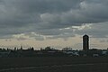 Klaaswaal, view of the village
 -
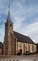 Reformed church


References[edit]
- ^ a b c "Kerncijfers wijken en buurten 2021". Central Bureau of Statistics. Retrieved 3 May 2022.
- ^ "Postcodetool for 3286AA". Actueel Hoogtebestand Nederland (in Dutch). Het Waterschapshuis. Retrieved 3 May 2022.
- ^ Ad van der Meer and Onno Boonstra, Repertorium van Nederlandse gemeenten, KNAW, 2011.
- ^ a b "Klaaswaal - (geografische naam)". Etymologiebank (in Dutch). Retrieved 3 May 2022.
- ^ Ronald Stenvert & Sabine Broekhoven (2004). "Klaaswaal" (in Dutch). Zwolle: Waanders. ISBN 90 400 9034 3. Retrieved 3 May 2022.
- ^ "Klaaswaal". Plaatsengids (in Dutch). Retrieved 3 May 2022.