Forres: Difference between revisions
No edit summary |
No edit summary |
||
| Line 2: | Line 2: | ||
The [[Royal Burgh]] of '''Forres''' ([[Scottish Gaelic language|Gaelic:]] ''Farrais''), an ancient [[burgh]], is situated in the north of [[Scotland]] on the [[Moray]] coast. |
The [[Royal Burgh]] of '''Forres''' ([[Scottish Gaelic language|Gaelic:]] ''Farrais''), an ancient [[burgh]], is situated in the north of [[Scotland]] on the [[Moray]] coast. |
||
==Brief History and Overview== |
|||
Forres is thought to be the "Varris" shown on maps by [[Ptolemy]] almost 2,000 years ago. There was a royal castle here from at least [[900]] AD and in around [[1140]] AD it became a royal burgh. Royal burghs were founded by the [[Kings of Scots]] of the [[12th century]] to encourage trade and economic improvement. The local [[abbey]] which was a powerhouse of growth soon took a hit as the infamous local warlord the [[Wolf of Badenoch]] plundered it. |
Forres is thought to be the "Varris" shown on maps by [[Ptolemy]] almost 2,000 years ago. There was a royal castle here from at least [[900]] AD and in around [[1140]] AD it became a royal burgh. Royal burghs were founded by the [[Kings of Scots]] of the [[12th century]] to encourage trade and economic improvement. The local [[abbey]] which was a powerhouse of growth soon took a hit as the infamous local warlord the [[Wolf of Badenoch]] plundered it. |
||
Revision as of 11:58, 18 October 2006

The Royal Burgh of Forres (Gaelic: Farrais), an ancient burgh, is situated in the north of Scotland on the Moray coast.
Brief History and Overview
Forres is thought to be the "Varris" shown on maps by Ptolemy almost 2,000 years ago. There was a royal castle here from at least 900 AD and in around 1140 AD it became a royal burgh. Royal burghs were founded by the Kings of Scots of the 12th century to encourage trade and economic improvement. The local abbey which was a powerhouse of growth soon took a hit as the infamous local warlord the Wolf of Badenoch plundered it.
On 23 June 1496 King James IV of Scotland issued a Royal Charter laying down the rights and privileges which the town's people are believed to have held by an earlier charter since the reign of King David I some 300 years earlier.
Forres has grown much in recent years and now has over 9,000 inhabitants. Sitting between the floodplain of the River Findhorn and the wooded slopes of Cluny and Sanquhar Hills, Forres is well known for its award winning floral sculptures and is steeped in local history and traditions.
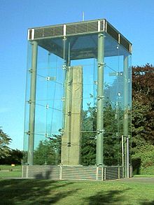
The town is the location of Sueno's Stone, an enormous carved stone, probably created by Picts to commemorate a battle against Norse invaders. Brodie Castle lies near the town.
Shakespeare's play Macbeth locates Macbeth's castle here, although there is little historical evidence of him living in the town.
The town of Forres was a very important junction in the Highland Railway network, travelling through Forres was once the quickest route to reach Inverness from the south.
The town has a network of footpaths that have been established and waymarked by the Forres Footpaths Trust in recent years.
Parliamentary burgh
Forres was a parliamentary burgh, combined with Inverness, Fortrose and Nairn, in the Inverness Burghs constituency of the House of Commons of the Parliament of Great Britain from 1708 to 1801 and of the Parliament of the United Kingdom from 1801 to 1918. The constituency was abolished in 1918 and the Forres and Nairn components were merged into the then new constituency of Moray and Nairn.
Education
- Andersons Primary School, High Street (State Primary School)
- Applegrove Primary School, Orchard Road (State Primary School)
- Pilmuir Primary School, Pilmuir Road (State Primary School)
- Forres Academy, Burdsyard Road (State Seconary School)
- Moray Steiner School, Drumduan House, Clovenside Road (Private School 5 to 16 year olds)
