
Ramiriquí: Difference between revisions
Tisquesusa (talk | contribs) +cat |
m En dash fix (via WP:JWB) |
||
| (20 intermediate revisions by 13 users not shown) | |||
| Line 9: | Line 9: | ||
|image_caption = Church of Ramiriquí |
|image_caption = Church of Ramiriquí |
||
|image_flag = Flag of Ramiriquí (Boyacá).svg |
|image_flag = Flag of Ramiriquí (Boyacá).svg |
||
|image_seal = |
|image_seal = |
||
|image_map = Colombia - Boyaca - Ramiriqui.svg |
|image_map = Colombia - Boyaca - Ramiriqui.svg |
||
|mapsize = 250px |
|mapsize = 250px |
||
|map_caption = Location of the municipality and town of Ramiriquí in the Boyacá |
|map_caption = Location of the municipality and town of Ramiriquí in the Boyacá department of Colombia |
||
|pushpin_map = |
|pushpin_map = |
||
|pushpin_mapsize = 300 |
|pushpin_mapsize = 300 |
||
| Line 23: | Line 23: | ||
|subdivision_name2 = [[Márquez Province]] |
|subdivision_name2 = [[Márquez Province]] |
||
|leader_title = Mayor |
|leader_title = Mayor |
||
|leader_name = |
|leader_name = José Moisés Aguirre Sanabria<br><small>(2020–2023)</small> |
||
|established_title = Founded |
|established_title = Founded |
||
|established_date = 21 December 1541 |
|established_date = 21 December 1541 |
||
| Line 48: | Line 48: | ||
|population_density_metro_sq_mi = |
|population_density_metro_sq_mi = |
||
|population_urban = 5023 |
|population_urban = 5023 |
||
|coordinates = |
|||
|latd=|latm=|lats= |latNS=N |
|||
|longd=|longm=|longs= |longEW=W |
|||
|timezone = Colombia Standard Time |
|timezone = Colombia Standard Time |
||
|utc_offset = -5 |
|utc_offset = -5 |
||
| Line 56: | Line 55: | ||
|elevation_m = 2325 |
|elevation_m = 2325 |
||
|elevation_ft = |
|elevation_ft = |
||
|website = [http://www.ramiriqui-boyaca.gov.co/ |
|website = [http://www.ramiriqui-boyaca.gov.co/ Official website] |
||
|footnotes = |
|footnotes = |
||
}} |
}} |
||
'''Ramiriquí''' is a town and municipality in the [[Colombia]]n [[Departments of Colombia|Department]] of [[Boyacá Department|Boyacá]], part of the subregion of the [[Márquez Province]]. Ramiriquí borders the department capital [[Tunja]] in the north, in the south [[Chinavita]] and [[Zetaquirá]], in the east [[Rondón, Boyacá|Rondón]] and [[Ciénaga, Boyacá|Ciénaga]] and in the west [[Chivatá]], [[Tibaná]] and [[Jenesano]].<ref name=website>{{es}} [http://www.ramiriqui-boyaca.gov.co/informacion_general.shtml Official website Ramiriquí] - accessed 02-05-2016</ref> |
'''Ramiriquí''' is a town and municipality in the [[Colombia]]n [[Departments of Colombia|Department]] of [[Boyacá Department|Boyacá]], part of the subregion of the [[Márquez Province]]. Ramiriquí borders the department capital [[Tunja]] in the north, in the south [[Chinavita]] and [[Zetaquirá]], in the east [[Rondón, Boyacá|Rondón]] and [[Ciénaga, Boyacá|Ciénaga]] and in the west [[Chivatá]], [[Tibaná]] and [[Jenesano]].<ref name=website>{{in lang|es}} [http://www.ramiriqui-boyaca.gov.co/informacion_general.shtml Official website Ramiriquí] - accessed 02-05-2016</ref> |
||
== Etymology == |
|||
Ramiriquí was named after the last ''cacique''; Ramirique. In the [[Chibcha language]] of the Muisca ''Ramirraquí'' means "white earth". An alternative etymology is ''Ca-mi-quiquí'' which means "our strength over the grasslands".<ref name=EtymologyMuisca>{{in lang|es}} [http://www.excelsio.net/2011/11/sabe-el-origen-del-nombre-de-su.html Etymology Ramiriquí] - accessed 02-05-2016</ref> |
|||
== History == |
== History == |
||
The area of Ramiriquí was inhabited by the [[Muisca people]] before the arrival of the [[Spanish conquest of the |
The area of Ramiriquí was inhabited by the [[Muisca people|Muisca]] before the arrival of the [[Spanish conquest of the Muisca|Spanish conquistadors]] on the [[Altiplano Cundiboyacense]] in the 1530s. The northern [[Muisca Confederation]] was ruled from nearby Hunza, present-day Tunja, after the [[Muisca mythology|mythological]] and brutal ''[[cacique]]'' [[Goranchacha]] moved the capital there from Ramiriquí. The first ruler of Hunza was [[Hunzahúa]] after whom the city was named. |
||
Second-last [[Muisca rulers|ruler]] [[Quemuenchatocha]] died in Ramiriquí, after he was beaten by Spanish [[conquistador]] [[Gonzalo Jiménez de Quesada]]. |
|||
| ⚫ | |||
| ⚫ | |||
| ⚫ | |||
| ⚫ | |||
== Economy == |
== Economy == |
||
Main economical activities in Ramiriquí are [[agriculture]] ([[uchuva]], [[tamarillo|tree tomatoes]], [[cucumber]]s, [[beans]], [[blackberry|blackberries]] and [[maize]]), fishing and [[crafts]]. |
Main economical activities in Ramiriquí are [[agriculture]] ([[uchuva]], [[tamarillo|tree tomatoes]], [[cucumber]]s, [[beans]], [[blackberry|blackberries]] and [[maize]]), fishing and [[crafts]]. |
||
== |
== Born in Ramiriqui == |
||
| ⚫ | |||
| ⚫ | |||
* [[José Patrocinio Jiménez]], former professional cyclist |
|||
| ⚫ | |||
| ⚫ | |||
{{Clear}} |
|||
== Gallery == |
== Gallery == |
||
<gallery> |
<gallery mode=packed heights=180px> |
||
File:Ramiriqui 05.JPG|Central square |
File:Ramiriqui 05.JPG|Central square |
||
File:Ramiriqui 02.JPG|Central square |
File:Ramiriqui 02.JPG|Central square |
||
File:Ramiriqui 01.JPG|Central square |
File:Ramiriqui 01.JPG|Central square |
||
</gallery> |
</gallery> |
||
<gallery> |
<gallery mode=packed heights=180px> |
||
File:Ramiriqui 03.JPG|Central square and church |
File:Ramiriqui 03.JPG|Central square and church |
||
File:Ramiriqui 04.JPG| |
File:Ramiriqui 04.JPG|Farmer monument |
||
File:Artesanias de Ramiriquí.jpg|Crafts in Ramiriquí |
|||
</gallery> |
</gallery> |
||
{{Clear}} |
|||
== References == |
== References == |
||
{{ |
{{Commons category|Ramiriquí}} |
||
{{ |
{{Reflist}} |
||
== External links == |
== External links == |
||
| Line 96: | Line 103: | ||
{{Municipalities boyaca department}} |
{{Municipalities boyaca department}} |
||
{{Authority control}} |
|||
{{ |
{{Coord|5|24|N|73|20|W|display=title|region:CO_type:city_source:GNS-enwiki}} |
||
{{DEFAULTSORT:Ramiriqui}} |
{{DEFAULTSORT:Ramiriqui}} |
||
[[Category:Municipalities of Boyacá Department]] |
[[Category:Municipalities of Boyacá Department]] |
||
[[Category:Populated places in |
[[Category:Populated places established in 1541]] |
||
[[Category:1541 establishments in the Spanish Empire]] |
[[Category:1541 establishments in the Spanish Empire]] |
||
[[Category:Populated places of the Muisca Confederation]] |
|||
Latest revision as of 07:41, 1 May 2024
Ramiriquí | |
|---|---|
Municipality and town | |
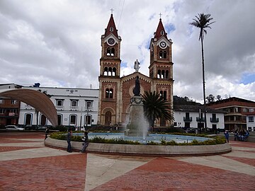
 Church of Ramiriquí | |
.svg) Flag | |
 Location of the municipality and town of Ramiriquí in the Boyacá department of Colombia | |
| Country | |
| Department | Boyacá Department |
| Province | Márquez Province |
| Founded | 21 December 1541 |
| Founded by | Pedro Durán |
| Government | |
| • Mayor | José Moisés Aguirre Sanabria (2020–2023) |
| Area | |
| • Municipality and town | 146.5 km2 (56.6 sq mi) |
| • Urban | 7.25 km2 (2.80 sq mi) |
| Elevation | 2,325 m (7,628 ft) |
| Population (2015) | |
| • Municipality and town | 10,015 |
| • Density | 68/km2 (180/sq mi) |
| • Urban | 5,023 |
| Time zone | UTC-5 (Colombia Standard Time) |
| Website | Official website |
Ramiriquí is a town and municipality in the Colombian Department of Boyacá, part of the subregion of the Márquez Province. Ramiriquí borders the department capital Tunja in the north, in the south Chinavita and Zetaquirá, in the east Rondón and Ciénaga and in the west Chivatá, Tibaná and Jenesano.[1]
Etymology[edit]
Ramiriquí was named after the last cacique; Ramirique. In the Chibcha language of the Muisca Ramirraquí means "white earth". An alternative etymology is Ca-mi-quiquí which means "our strength over the grasslands".[2]
History[edit]
The area of Ramiriquí was inhabited by the Muisca before the arrival of the Spanish conquistadors on the Altiplano Cundiboyacense in the 1530s. The northern Muisca Confederation was ruled from nearby Hunza, present-day Tunja, after the mythological and brutal cacique Goranchacha moved the capital there from Ramiriquí. The first ruler of Hunza was Hunzahúa after whom the city was named.
Second-last ruler Quemuenchatocha died in Ramiriquí, after he was beaten by Spanish conquistador Gonzalo Jiménez de Quesada.
The modern town was founded on December 21, 1541 by Spanish friar Pedro Durán.
Within the boundaries of Ramiriquí petroglyphs have been found.[3]
Economy[edit]
Main economical activities in Ramiriquí are agriculture (uchuva, tree tomatoes, cucumbers, beans, blackberries and maize), fishing and crafts.
Born in Ramiriqui[edit]
- Jose Ignacio de Marquez, first civil Colombian president
- José Patrocinio Jiménez, former professional cyclist
- Mauricio Soler, former international cyclist
Gallery[edit]
-
 Central square
 -
 Central square
 -
 Central square


-
 Central square and church
 -
 Farmer monument


References[edit]
- ^ (in Spanish) Official website Ramiriquí - accessed 02-05-2016
- ^ (in Spanish) Etymology Ramiriquí - accessed 02-05-2016
- ^ (in Spanish) Petroglyphs in Ramiriquí - accessed 02-05-2016
External links[edit]
| International | |
|---|---|
| National | |