Linua
| Linua | ||
|---|---|---|
|
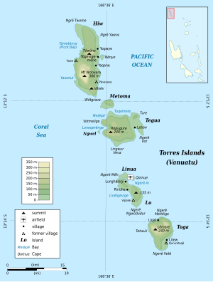
Map of the Torres Islands Linua in the center of the picture |
||
| Waters | Coral sea | |
| Archipelago | Torres Islands | |
| Geographical location | 13 ° 19 '36 " S , 166 ° 37' 55" E | |
|
|
||
| length | 2.7 km | |
| width | 900 m | |
| surface | 2.5 km² | |
| Highest elevation | 26 m | |
| main place | uninhabited | |
Linua , sometimes also called Linaua , is an uninhabited island in the Pacific island state of Vanuatu . It is located six kilometers south of the island of Tegua in the center of the Torres Islands , which politically belong to the Vanuatu province of Torba .
The island extends from west to east for about 2.7 kilometers and is a maximum of 900 meters wide. Linua is only separated from its neighboring island of Loh to the south by a flat sandbank about 100 m wide . A passage on foot is possible except during high tide .
Linua is home to the small airfield of the Torres Islands, the Linua Airfield , also known as the Torres Airstrip (TOH).
Apart from a few holiday huts built for tourists in the west of the island, Linua is uninhabited.
Individual evidence
- ↑ Michelle Bennett, Jocelyn Harewood: Vanuatu , p. 164
- ↑ Airport data in the Aviation Safety Network (English)
- ^ Jocelyn Harewood: Vanuatu and New Caledonia , p. 96

