
Iron Gate (lake)
| Iron Gate - lake | |||||||||
|---|---|---|---|---|---|---|---|---|---|
 |
|||||||||
|
|||||||||
|
|||||||||
| Coordinates | 44 ° 40 '17 " N , 21 ° 38' 34" E | ||||||||
| Data on the structure | |||||||||
| Construction time: | 1972 | ||||||||
| Data on the reservoir | |||||||||
| Altitude (at congestion destination ) | approx. 65 m | ||||||||
| Water surface | 253 km² | ||||||||
| Reservoir length | 150 km | ||||||||
| Reservoir width | 2-8 km | ||||||||
| Particularities: |
largest lake in Serbia |
||||||||

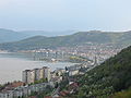
The Iron Gate lake ( Romanian Lacul Porțile de Fier , Serbian Đerdapsko jezero or Ђердапско језеро ) is an artificially created reservoir on the Danube in the Romanian - Serbian border area. It was created in 1972 when Yugoslavia and Romania built the Iron Gate 1 power station . The lake is in front of and in the breakthrough valley " Iron Gate ".
The lake is over 150 km long and 5.5 km at its widest point, but is mostly much narrower. At its deepest point, it is over 120 m deep. The water level is a maximum of 69.5 meters above sea level, which results in a net drop at the power plant of 27.16 meters. The area of the lake is 253 km², of which 163 km² are on Serbian and 90 km² on Romanian territory. This makes it the fourth largest lake on the Balkan Peninsula and also the largest lake in Serbia and the third largest in Romania. It is about half the size of Lake Constance .

Valley breakthrough between Romania and Serbia
Reservoir in Orșova


See also
Web links
Individual evidence
- ↑ http://www.djerdap.rs/sr/page/33/HE+%C4%90erdap+1 Technical data of the barrage