İğneada
| İğneada | ||||
|
||||
| Basic data | ||||
|---|---|---|---|---|
| Province (il) : | Kırklareli | |||
| District ( ilçe ) : | Demirkoy | |||
| Coordinates : | 41 ° 53 ' N , 27 ° 59' E | |||
| Residents : | 2,694 (2018) | |||
| Telephone code : | (+90) 288 | |||
| Postal code : | 39 xxx | |||
| License plate : | 39 | |||
| Structure and administration (as of 2019) | ||||
| Mayor : | Tahir Işık ( AKP ) | |||
| Website: | ||||
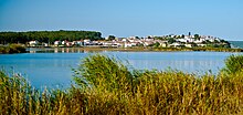
İğneada (Thracian Thynias , Latin Thynius propontis ) is a place in eastern Thrace near Demirköy in the province of Kırklareli on the Turkish Black Sea coast .
İğneada lies close to the Bulgarian border and is geographically cut off from the rest of the country by the Yıldız Mountains (formerly Thynia ). It can only be reached via the Edirne - Demirköy road or by boat via the port in the neighboring town of Limanköy.
Historically İğneada is a Thracian settlement of the Thynen tribe , from which its old name is derived.
Bulgarians lived here until 1913, but they were expelled in the Second Balkan War (see Thracian Bulgarians ).
The Black Sea is a bit dangerous here because of its strong currents. There are extensive forests in the hinterland.


