A894 road
| A894 road in the UK | ||||||||||||||||||||||||||||||||||||||||||||||
| map | ||||||||||||||||||||||||||||||||||||||||||||||
| Basic data | ||||||||||||||||||||||||||||||||||||||||||||||
| Operator: | ||||||||||||||||||||||||||||||||||||||||||||||
| Start of the street: | Skiag Bridge ( 58 ° 10 ′ N , 5 ° 0 ′ W ) |
|||||||||||||||||||||||||||||||||||||||||||||
| End of street: | Laxford Bridge ( 58 ° 22 ′ N , 5 ° 1 ′ W ) |
|||||||||||||||||||||||||||||||||||||||||||||
| Overall length: | 37.3 km (23.2 mi ) | |||||||||||||||||||||||||||||||||||||||||||||
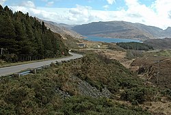
| View of Loch Glendhu, north of Kylestrome | ||||||||||||||||||||||||||||||||||||||||||||||
|
Course of the road
|
||||||||||||||||||||||||||||||||||||||||||||||
The A894 road is an A-road in the Scottish Council Area Highland . It is part of the north-south connection along the west coast through the Northwest Highlands between Ullapool and Durness on the Scottish north coast.
course
The two-lane road starts at Skiag Bridge , the junction of the A837 on the north bank of Loch Assynt . From there it climbs northwards through largely uninhabited mountainous areas to around 260 meters above sea level. Eas a 'Chual Aluinn , the highest waterfall in Great Britain, can be reached after a long hike from a parking lot about three miles north of Skiag Bridge . From the parking lot, the A894 leads downhill again, partly in serpentines, to the small village of Unapool. About two kilometers earlier, a narrow single track road branches off to the left , which opens up the small settlements in the north-west of Assynt . Shortly after Unapool, the A894 passes Kylesku , a small town on the south bank of Loch Glencoul . Loch Glencoul is a sea loch and part of a deeply cut into the land, consisting of Loch a 'Chàirn Bhàin , Loch Glencoul and Loch Glendhu , belonging to the Minch fjord .
Until 1984 the A894 crossed the fjord by ferry between Kylesku and the small settlement Kylestrome on the north side. In August 1984, Queen Elizabeth II opened the Kylesku Bridge , a 277 meter long box girder bridge that reaches 24 meters above sea level. It runs in a curve and is supported on both banks on V-shaped supports. Together with the construction of the bridge, the A894 was also neutralized in this area.
North of the bridge, the A894 passes the junction to Kylestrome, which is also the former course of the A894. In this area there is also a lookout point from which a wide view of the fjord and the mountains in northern Assynt is possible. The following section was fundamentally expanded and re-routed in the 1970s, the new route deviating in part by several kilometers from the previous route. The old sections partly serve as access to small settlements and lodges, but are mostly no longer passable. As far as Scourie , the largest town on the A894, the road mostly runs to the northwest with a little distance from the coast. From Scourie it turns to the northeast. She passes several lakes in this area. At Loch a 'Bhagh Ghainmhich a small side street branches off, via which the small port of Tarbet can be reached, from which there is a boat connection to the island of Handa , an important breeding area for sea birds. After the small settlement of Badnabay, the A894 ends at Laxford Bridge where it joins the A 838 . Coming from the south of Lairg , this continues north to Durness and from there to the east along the north coast to Tongue .
Between the junction of the B869 south of Unapool and Laxford Bridge, the A894 is part of the North Coast 500 holiday route .
Web links
Individual evidence
- ↑ DKL Miles: Bridge Engineering 2 report.docx - A_Critical_Analysis_of_Kylesku_Bridge.pdf. (PDF; 920 kB) In: bath.ac.uk. University of Bath, April 2011, accessed October 4, 2018 .
- ↑ northcoast500.com: Route map , accessed on February 27, 2020

