Aa (Möhne)
| Aa | ||
|
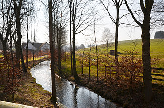
The Aa at the third Aamühle |
||
| Data | ||
| Water code | DE : 276212 | |
| location | Brilon , Hochsauerlandkreis , North Rhine-Westphalia ( Germany ) | |
| River system | Rhine | |
| Drain over | Möhne → Ruhr → Rhine → North Sea | |
| source | in Altenbüren 51 ° 23 ′ 11 ″ N , 8 ° 30 ′ 25 ″ E |
|
| Source height | approx. 459 m above sea level NHN | |
| muzzle | near Brilon in the Möhne Coordinates: 51 ° 25 ′ 7 " N , 8 ° 34 ′ 59" E 51 ° 25 ′ 7 " N , 8 ° 34 ′ 59" E |
|
| Mouth height | approx. 387 m above sea level NHN | |
| Height difference | approx. 72 m | |
| Bottom slope | approx. 9.7 ‰ | |
| length | 7.4 km | |
| Catchment area | 23.071 km² | |
| Left tributaries | Fülsenbecke | |
| Right tributaries | Hillbringse | |
The Aa is a 7.4 km long, southwest and orographically left tributary of the Möhne in the urban area of Brilon in North Rhine-Westphalia Hochsauerlandkreis ( Germany ).
geography
course
The source of the Aa is in Altenbüren , a western district of Brilon . It is located at about 459 m above sea level. NHN near the intersection of Briloner Tor ( B 7 ) and Johannes- / Warenbergstraße .
Initially, the Aa flows in an east-northeast direction, partly in the Altenbürener sewer system. Before the 473 m high Hexenstein , on which the nature reserve Hexenstein lies, it turns its course to the north. At the Seeschultenmühle there, one of five former Aamühlen in the Aatal, the Hilbringse flowing from the south joins . Then the Aa passes the Obermühle and the Kleinschmidtsmühle, from where it turns to the northeast. After passing the Michelsmühle and the Brandige Mühle, the Fülsenbecke, coming from the northwest, flows behind the Niederen Mühle on the left . In the following section of the stream the Aa disappeared until the Schwalchloch was sealed in the Brilon mass limestone . Today it flows above ground in a northeasterly direction.
Then the Aa flows into the Möhne Ruhr tributary coming from the south-south-east near the Brilon settlement of Fünf Brücken . Its confluence is 2.9 km north-northeast of the Church of St. Petrus and Andreas in the center of Brilon, at an altitude of about 387 m . The Aa overcomes a height difference of 72 m, which corresponds to an average bed gradient of 9.7 ‰.
Catchment area and tributaries
The catchment area of the Aa is 23,071 km² . Its tributaries include, with orographic allocation (l = left-hand side, r = right-hand side), length of the water, location and height of the mouth and - if known - the size of the catchment area and the Aa stream kilometers (viewed downstream):
- Hillbringse (r; 4.6 km, above the Seeschultenmühle, at 430 m , at km 5.2; 6.957 km²)
- nameless (l; 1.5 km, below the Kleinschmidtsmühle, at 421 m , at km 4)
- Fülsenbecke (l; 1.6 km, below the Niedere Mühle, at 411 m , near km 2.8; 92.2 ha)
Others
More recently, the Möhne spring was set on the northern slope of the Poppenberg . At the confluence with the Aa, this stream was called Hunderbecke until recently, so that the Aa can be considered one of the source rivers of the Möhne. The representation as their inflow follows the representation published today by the Land Survey Office of North Rhine-Westphalia .
Web links
- Aa history , on openstreetmap.org
